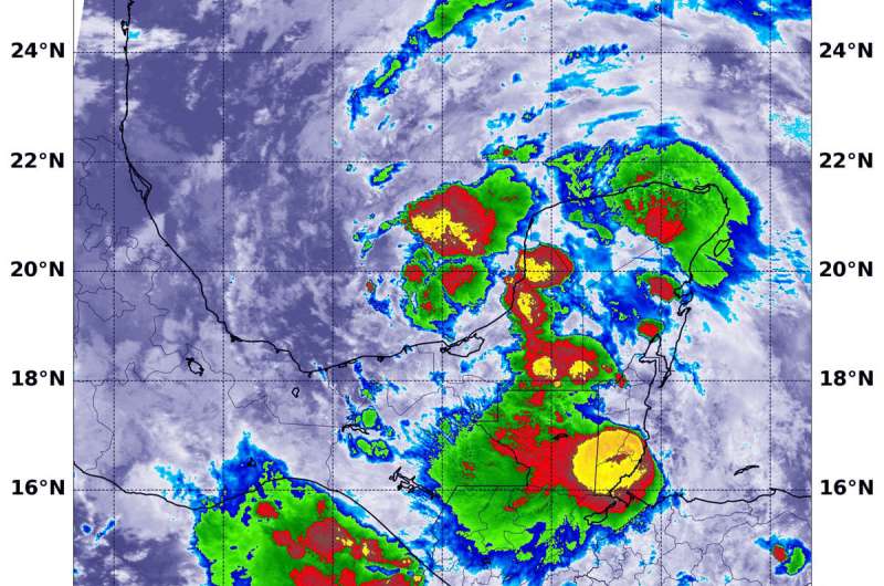
On June 2 at 3:35 a.m. EDT (0735 UTC) the MODIS instrument that flies aboard NASA's Aqua satellite found coldest cloud top temperatures (yellow) in several areas around Tropical Depression 03L's center of circulation. They were as cold as or colder than minus 80 degrees Fahrenheit (minus 62.2 Celsius). One area of strong storms were off the coast and over the Bay of Campeche, Gulf of Mexico. Several other areas were over Mexico's Yucatan Peninsula. Credit: NASA/NRL
Infrared imagery from NASA's Aqua satellite showed that strong storms from a redeveloped tropical cyclone were soaking parts of Mexico's Yucatan Peninsula. Tropical Depression 03L is expected to generate heavy rainfall in the region.
On June 2, a Tropical Storm Warning is in effect from Campeche to Puerto de Veracruz, Mexico.
The Atlantic Ocean saw the development of Tropical Depression 03L on June 2 in the Bay of Campeche, Gulf of Mexico. However, it is not the first go-round for this system, though. Tropical Depression 03L formed from a former eastern Pacific Ocean tropical storm. On Sunday, May 31, Tropical Storm Amanda,that formed along the coast of Guatemala made landfall and dissipated over land. The remnants moved north and slid into the Bay of Campeche where it reformed into a tropical depression in the Atlantic Ocean basin, getting the number 03L.
Tropical cyclones/hurricanes are made of up hundreds of thunderstorms, and infrared data can show where the strongest storms are located. They can do that because infrared data provides temperature information, and the strongest thunderstorms that reach highest into the atmosphere have the coldest cloud top temperatures. Convection is rising air that condenses and forms the thunderstorms that make up a tropical cyclone. When it is strong, it pushes clouds higher into the troposphere (the layer of atmosphere closest to Earth's surface). The higher you go in the troposphere, the colder the air temperature gets, so colder cloud tops indicate stronger, higher storm cloud tops.
On June 2 at 3:35 a.m. EDT (0735 UTC), the Moderate Resolution Imaging Spectroradiometer or MODIS instrument that flies aboard NASA's Aqua satellite found coldest cloud top temperatures in several areas around Tropical Depression 03L's center of circulation. They were as cold as or colder than minus 80 degrees Fahrenheit (minus 62.2 Celsius). One area of strong storms were off the coast and over the Bay of Campeche, Gulf of Mexico. Several other areas were over Mexico's Yucatan Peninsula. NASA research has found that cloud top temperatures that cold indicate strong storms with the potential to generate heavy rainfall.
That life-threatening heavy rainfall and flooding continues over portions of Mexico and Central America, according to the National Hurricane Center (NHC).
NHC said, "Tropical Depression Three is expected to produce total rain accumulations of 10 to 20 inches with isolated maximum amounts of 25 inches over parts of the Mexican states of Tabasco, Veracruz, and Campeche. The depression is also expected to produce total rain accumulations of 10 to 15 inches over northern Chiapas and other Mexican states, Quintana Roo and Yucatan. Additional rainfall of 10 to 15 inches, with isolated amounts of 25 inches is expected along the Pacific coasts of Chiapas, Guatemala, and El Salvador. Some of these Pacific locations received 20 inches of rain over the weekend, and storm total amounts of 35 inches are possible. Rainfall in all of these areas may produce life-threatening flash floods and mudslides."
At 11 a.m. EDT (1500 UTC), on June 2, the center of Tropical Depression 03L was located near latitude 19.5 degrees north and longitude 92.6 west. That is about 140 miles (225 km) west of Campeche Mexico.
The depression is moving toward the west near 3 mph (6 kph). The depression is forecast to move slowly southwestward or southward this afternoon and tonight, and meander over the southern Bay of Campeche through late Wednesday. On the forecast track, the center of the cyclone is forecast to be near the coast of the southern Bay of Campeche tonight through Thursday. Maximum sustained winds are near 35 mph (55 kph) with higher gusts. Some strengthening is forecast during the next 48 hours, and the depression is likely to become a tropical storm today. The minimum central pressure reported by an Air Force Hurricane Hunter plane is 1005 millibars.
Tropical cyclones/hurricanes are the most powerful weather events on Earth. NASA researches these storms to determine how they rapidly intensify, develop and behave. NASA's expertise in space and scientific exploration contributes to essential services provided to the American people by other federal agencies, such as hurricane weather forecasting.
Provided by NASA's Goddard Space Flight Center


