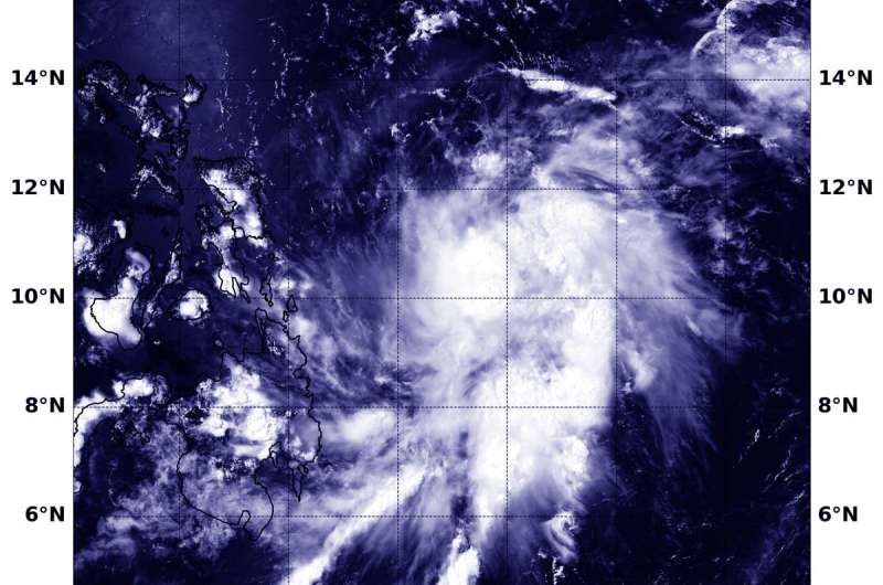
NASA sees Tropical Storm Vongfong form and threaten the Philippines

A low-pressure area that formed in the Northwestern Pacific Ocean several days ago has consolidated and organized into a tropical storm. NASA's Aqua satellite provided forecasters with a visible image of newly formed Tropical Storm Vongfong.
Vongfong, known locally as Ambo in the Philippines, threatens that country, according to the forecasts from the Joint Typhoon Warning Center or JTWC. The storm is also the first of tropical cyclone of the Northwestern Pacific Ocean typhoon season.
On May 12, the Moderate Resolution Imaging Spectroradiometer or MODIS instrument that flies aboard NASA's Aqua satellite provided a visible image of Vongfong that showed the storm had a more rounded shape than it did the previous day, as it continued to consolidate. A more rounded shape in a tropical cyclone indicates it is becoming a more organized storm. Infrared satellite imagery also indicated cooling cloud top temperatures, which means that cloud tops are extending higher into the troposphere. The higher the cloud top, the stronger the uplift of air in a storm, and usually, the stronger the storm.
At 11 a.m. EDT (1500 UTC) on May 12, the JTWC noted that Vongfong had maximum sustained winds near 35 knots (40 mph/65 kph) with higher gusts. It was located near latitude 11.4 degrees north and longitude 128.8 degrees east, about 495 miles east-southeast of Manila, Philippines. Vongfong was moving to the north-northwest.
JTWC forecasters expect Vongfong (Ambo) will move west-northwest, and then later northwest before finally turning to the north. The storm is expected to strengthen to typhoon force with maximum sustained winds near 65 knots (75 mph/120 kph) as it passes over the Philippines archipelago.
PAGASA, Philippine Atmospheric, Geophysical and Astronomical Services Administration, the entity that issues forecasts and warnings for the country noted, "Between tonight and tomorrow (13 May) evening, Ambo (Vongfong) will bring scattered light to moderate with at times heavy rain showers during thunderstorms over Mindanao and Eastern Visayas. Between tomorrow evening and Thursday (14 May) evening, Ambo (Vongfong) will bring moderate to heavy rains over Eastern Visayas, Catanduanes, Albay, Sorsogon, and Masbate. Tropical Cyclone Wind Signal (TCWS) #1 may be raised over Eastern Samar and the eastern portion of Northern Samar in the next 6 to 12 hours in anticipation of strong winds associated with the approaching tropical storm."
NASA's Aqua satellite is one in a fleet of NASA satellites that provide data for hurricane research.
Tropical cyclones/hurricanes are the most powerful weather events on Earth. NASA's expertise in space and scientific exploration contributes to essential services provided to the American people by other federal agencies, such as hurricane weather forecasting.
More information: For additional forecasts and updates from PAGASA, visit: http://bagong.pagasa.dost.gov.ph/
Provided by NASA's Goddard Space Flight Center


