NASA examines tropical storm Arthur's rainfall as it transitions

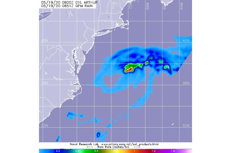
When the Global Precipitation Measurement mission or GPM core satellite passed over the western North Atlantic Ocean, it captured rainfall data on Tropical Storm Arthur as the storm was transitioning into an extra-tropical storm.
The GPM's core satellite passed over Arthur on May 19 at 2:51 a.m. EDT (0651 UTC) and found the heaviest rainfall on the northeastern side of the storm falling at a rate of over 25mm (over 1 inch) per hour. Lighter rainfall rates were measured throughout the rest of the storm. Forecasters at NOAA's National Hurricane Center or NHC incorporate the rainfall data into their forecasts.
NHC forecasters noted at 5 a.m. EDT (0900 UTC) on May 19, "Arthur's cloud pattern has continued to take on a generally post-tropical appearance, though a recent convective burst near its center suggests that it isn't quite post-tropical yet. Satellite imagery and earlier scatterometer data also indicate the presence of a developing warm front near the cyclone's center, and this could be contributing the development of the aforementioned convective burst."
NHC said the center of Tropical Storm Arthur was located near latitude 37.0 north, longitude 70.6 west, about 300 miles (485 km) east-northeast of Cape Hatteras, North Carolina. Arthur was moving toward the east-northeast near 15 mph (24 kph). Maximum sustained winds are near 60 mph (95 kph) with higher gusts. The estimated minimum central pressure is 991 millibars.
The NHC cautions that swells generated by Arthur are expected to affect portions of the mid-Atlantic and southeast U.S. coasts during the next day or two. These swells could cause life-threatening surf and rip current conditions.
Arthur is forecast to become post-tropical later today and is forecast to slow down and turn toward the south in another day or so. Arthur is expected to dissipate by the end of the week.
A Post-Tropical Storm is a generic term for a former tropical cyclone that no longer possesses sufficient tropical characteristics to be considered a tropical cyclone. Former tropical cyclones that have become extratropical, subtropical, or remnant lows are all three classes of post-tropical cyclones. In any case, they no longer possesses sufficient tropical characteristics to be considered a tropical cyclone. However, post-tropical cyclones can continue carrying heavy rains and produce high winds.
Provided by NASA's Goddard Space Flight Center


