NASA examines Tropical Storm Uesi's heavy rainfall

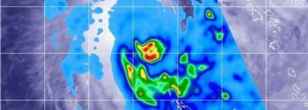
NASA analyzed Tropical Storm Uesi's rainfall and found moderate to heavy rainfall around the storm's center and in a large band of thunderstorms south of the center. That heavy rainfall has triggered warnings for Vanuatu in the Southern Pacific Ocean.
NASA has the unique capability of peering under the clouds in storms and measuring the rate in which rain is falling. The Global Precipitation Measurement mission or GPM core passed over Uesi from its orbit in space and measured rainfall rates throughout the storm on Feb. 10 at 2:31 a.m. EST (0731 UTC).
The heaviest rainfall around the center was falling at a rate of 1.2 inches (30 mm) per hour. In a large band of thunderstorms south of the center, rainfall occurring at a rate of 1 inch (25 mm) per hour. Light rain was occurring throughout the rest of the storm.
On Feb. 10, the Vanuatu Meteorology and Geo-Hazards Department (VMGD), in Port Vila issued an update on Uesi. At 7 a.m. EST (11 p.m. Vanuatu local time), Tropical Cyclone Uesi was located at latitude 17.6 degrees south and longitude 162.4 east, about 348 miles (560 km) west southwest of Malekula. Winds close to the center of the system were estimated near 55 mph (90 kph/50 knots) and Uesi was moving in a southwest direction.
VMGD's latest update said, "Rainfalls will be heavy with flash flood over low lying areas and areas close to river banks, including coastal flooding expected about the islands of the northern and parts of the central provinces. The marine strong wind warning is in effect for all Vanuatu coastal waters, while High seas warning is current for the central waters. Very rough to phenomenal seas and heavy to phenomenal swells expected to continue to affect the western parts of the northern and central waters tonight and tomorrow and extending to southern waters thereafter. People, including sea going vessels are strongly advised not to go out to sea until the system has moved out of the area."
The National Disaster Management Office (NDMO) posted a Blue Alert for the SHEFA and TAFEA provinces.
Provided by NASA's Goddard Space Flight Center


