New map of the seabed reveal more deposits than expected

There are 30 percent more sediments on the seabed than previously expected, reveal an update of the map GlobSed. This equates to up to two kilometers of extra land mass over today's land area.
As much as 70 percent of the Earth's surface is covered by oceans. The seabed itself, which is part of the Earth's crust (lithosphere), has been extensively investigated over the past decades and even centuries, but is only recently coming into focus. The crust varies in thickness depending on where you measure, and is thickest at the continental shelves and thinnest at the so-called mid-ocean ridges where new seabed forms. But the sea also contains a lot of material that slowly accumulates on top of these rocks—on the seabed—and eventually becomes sedimentary rocks.
"The sedimentary rocks are a product of biological marine processes and/or erosion on land. The continuously ongoing geological processes produce large quantities of loose particles that are transported and deposited on the seabed by winds and ocean currents," explains Eivind Straume, one of the researchers behind the update.
The thickness of deposits on the seabed has previously been mapped in 2003, 2013 and was due for an update. The last update, published earlier this year, was made by an international research team, where several researchers from the the University of Oslo, Norway and its Centre of Excellence CEED have participated. The update was led by Eivind Straume, Ph.D. Fellow at CEED.
The research team combined several new regional and global maps with previously published maps. They have also included new areas in the map.
"The update is the first truly global map showing the thickness of sediments in that we have now covered the Nordic oceans and the Arctic Ocean," says Straume to Titan.uio.no.
Thickest near the Poles and Equator
Using mathematical calculations based on the new map, the researchers deduced a formula to calculate the sediment thickness globally and in the various oceans using only the age of the seabed and the latitude.
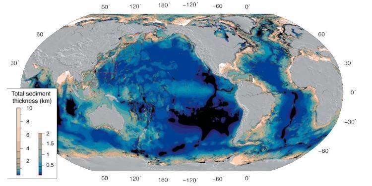
The researchers found that the thickness of sediments on the seabed is thinnest in middle latitudes (between 30° and 60° latitude of the South and North hemispheres), and increases toward both the Poles and Equator, see the illustration above. Dark colors show sediments of low-thickness, and lighter colours represent areas with thick sediments, up to 10 kilometer thick.

Using the new formula derived from the sediment distribution in today's oceans, the scientists were able to calculate how deep the oceans were in the geological past, revealing something about processes that have operated for millions of years.
They also found that the total amount of sediments in the World's oceans is much larger than previously thought, almost 30 percent more!
The researchers have estimated the volume of the sediments on the seabed to be 337 million cubic kilometers. This equates to approximately 2 kilometers of extra land mass (over today's land area).
The age and the latitude is of importance
The researchers based the update on several different sources. Data was used from drill core surveys from 26 points on the Indian Ocean seabed, as well as 10 drill cores from the North Atlantic. They have also used data from seismic surveys of the seabed.
After compiling the data, the researchers confirmed that the distribution of the thickness of the sediments on the seabed depends on the age and latitude of the sea basins.
They confirmed a long-standing hypothesis in Earth Science that older parts of the Earth's crust—also applicable to the age of the seabed– also had thicker layers of sediments.
Interesting for several research groups
The update of the GlobSed map is based on the efforts of researchers from several European countries and Australia.
The map is of interest to those who study the structure of the Earth, including the relationship between the sea and land in terms of the deposits, and the depositional processes in the sea itself. As we know, sediments can contain resources such as oil and gas, they can tell us the age of geological formations, and provide knowledge about the world's environment back in time.
More information: E. O. Straume et al. GlobSed: Updated Total Sediment Thickness in the World's Oceans, Geochemistry, Geophysics, Geosystems (2019). DOI: 10.1029/2018GC008115
Provided by University of Oslo


