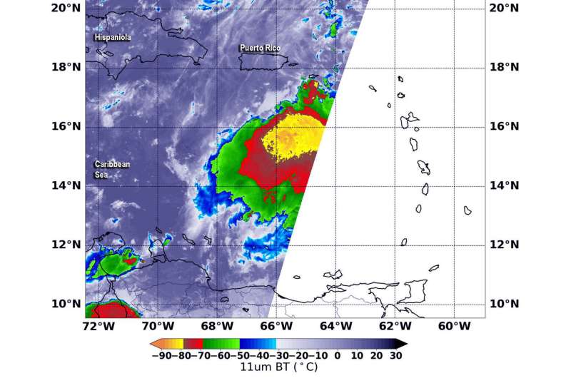
NASA-NOAA's Suomi NPP satellite passed over Tropical Storm Karen and the VIIRS instrument aboard captured this image of the storm on Sept. 24 at 2:48 a.m. EDT (0648 UTC). Suomi NPP found that the strongest thunderstorms around the center had cloud top temperatures as cold as minus 80 degrees Fahrenheit (minus 62.2 degrees Celsius) appearing in yellow. Those storms were surrounded by strong storms with cloud top temperatures as cold as (red) minus 70 degrees Fahrenheit (minus 56.6 Celsius). Credit: NASA/NOAA/NRL
NASA-NOAA's Suomi NPP satellite passed over the Caribbean Sea and used infrared light to obtain temperature information about Karen's cloud tops. Data showed powerful thunderstorms re-developed in around the storm's center as it strengthened back into a tropical storm.
NASA-NOAA's Suomi NPP satellite used infrared light to analyze the strength of storms within the structure of what was Tropical Depression Karen. Infrared data provides temperature information, and the strongest thunderstorms that reach high into the atmosphere have the coldest cloud top temperatures. This data is helpful to forecasters because storms are not uniform around tropical cyclones and it helps pinpoint where the strongest storms are located.
On Sept. 24 at 2:48 a.m. EDT (0648 UTC), the Visible Infrared Imaging Radiometer Suite (VIIRS) instrument aboard the Suomi NPP satellite found that the strongest thunderstorms around Karen's center had cloud top temperatures as cold as minus 80 degrees Fahrenheit (minus 62.2 degrees Celsius) appearing in yellow. Those storms were surrounded by strong storms with cloud top temperatures as cold as minus 70 degrees Fahrenheit (minus 56.6 Celsius).
NASA research has shown that storms with cloud top temperatures as cold as or colder than minus 63 degrees Fahrenheit (minus 53 degrees Celsius) have the ability to produce heavy rainfall. Karen has a large area of storms around the center with temperatures colder than that threshold.
At 8 a.m. EDT (1200 UTC) those heavy rains were already lashing Virgin Islands, Culebra, and Vieques.
A Tropical Storm Warning is in effect for U.S. Virgin Islands, Puerto Rico, including Vieques and Culebra, and the British Virgin Islands. NOAA's National Hurricane Center (NHC) said Karen is expected to produce the following rainfall accumulations through Wednesday: Puerto Rico and the Virgin Islands are forecast to get from 2 to 4 inches of rain with isolated totals to 8 inches. The Leeward Islands are expected to receive between 1 to 3 inches, with isolated totals to 5 inches.
At 8 a.m. EDT (1200 UTC), the center of Tropical Storm Karen was located by an Air Force Reserve Hurricane Hunter aircraft near latitude 17.2 degrees north and longitude 65.8 degrees west. That is about 85 miles (120 km) south of San Juan, Puerto Rico. Karen is moving toward the north at near 7 mph (11 kph), and this general motion is expected to continue today. Maximum sustained winds are near 40 mph (65 kph) with higher gusts. The minimum central pressure just reported by the Hurricane Hunter aircraft is 1006 millibars.
NHC said that strengthening is forecast during the next 48 hours. A north-northeastward motion is forecast tonight through Wednesday night. On the forecast track, the center of Karen will pass near or over Puerto Rico and the Virgin Islands today, and then move over the western Atlantic tonight and Wednesday.
Hurricanes are the most powerful weather event on Earth. NASA's expertise in space and scientific exploration contributes to essential services provided to the American people by other federal agencies, such as hurricane weather forecasting.
Provided by NASA's Goddard Space Flight Center


