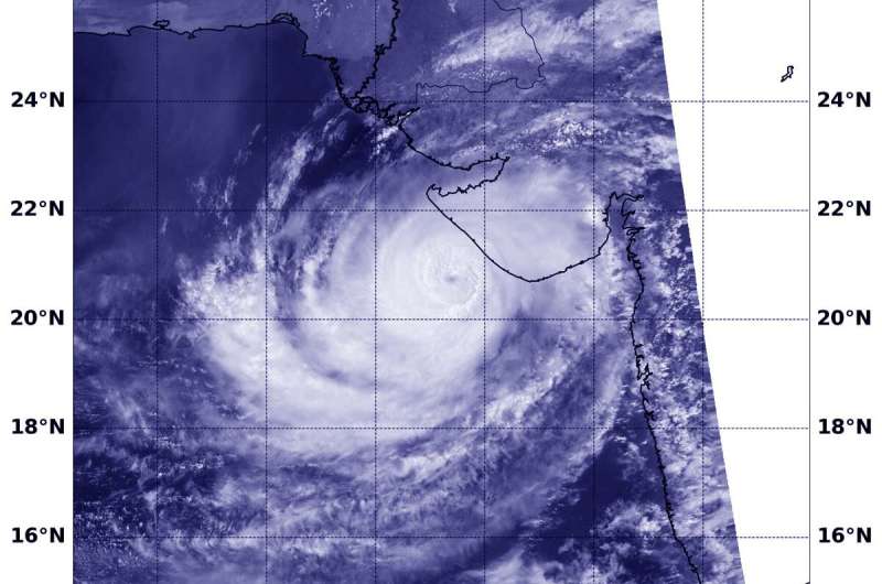
NOAA's JPSS satellite passed over the Northern Indian Ocean and the VIIRS instrument captured a visible image that showed the eye off the Gujurat coast of India. Credit: NOAA/NRL
Tropical Cyclone Vayu's eye was just off the western coast of India when the NOAA-20 satellite passed overhead and captured a visible image of the storm.
The Visible Infrared Imaging Radiometer Suite (VIIRS) instrument aboard the NOAA-20 polar orbiting satellite provided a visible image of the storm. The VIIRS image revealed an eye surrounded by powerful thunderstorms. However, the majority of the strongest storms appeared to be displaced southwest of the eye.
The Joint Typhoon Warning Center or JTWC noted that dry air is wrapping into the system, which will limit its ability to intensify further.
At 11 a.m. EDT (1500 UTC) on June 13, 2019, Vayu had maximum sustained winds near 95 knots (109 mph/176 kph). Vayu's eye was centered near 20.9 degrees north latitude and 68.8 degrees east longitude. It is approximately 264 nautical miles south-southeast of Karachi, Pakistan. Vayu has tracked north-northwestward.
JTWC forecasters noted that "the track is expected to shift westward in the near term as another subtropical ridge (elongated area of high pressure) located over Saudi Arabia builds in to the northwest. In one and a half days, increasing outside winds and more dry air moving into the system is expected to begin weakening it.
Provided by NASA's Goddard Space Flight Center


