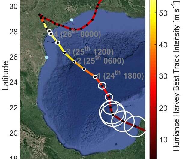
New research explains why Hurricane Harvey intensified immediately before landfall

A new study explains the mechanism behind Hurricane Harvey's unusual intensification off the Texas coast and how the finding could improve future hurricane forecasting.
Hurricanes are fueled by heat they extract from the upper ocean. But hurricane growth often stalls as the storms approach land, partly because as the ocean gets shallower, there is less water and therefore less heat available to the storm. As a result, most hurricanes weaken or stay the same strength as they get close to making landfall.
But Hurricane Harvey intensified from a Category 3 storm to a Category 4 as it neared the Texas shore in late August 2017, and scientists have been puzzled as to why it was different. In a new study, researchers at Texas A&M University compared ocean temperatures in the Texas Bight, the shallow waters that line the Gulf Coast, before and after Harvey passed through it.
They found the Bight was warm all the way to the seabed before Harvey arrived. Strong hurricane winds mix the ocean waters below the storm, so if there is any cold water below the warm water at the surface, the storm's growth will slow. But there wasn't any cold water for Harvey to churn up as it neared the coast, so the storm continued to strengthen right before it made landfall, according to the study's authors.
"When you have hurricanes that come ashore at the right time of year, when the temperature is particularly warm and the ocean is particularly well-mixed, they can absolutely continue to intensify over the shallow water," said Henry Potter, an oceanographer at Texas A&M and lead author of the new study in AGU's Journal of Geophysical Research: Oceans.
The researchers don't yet have enough temperature data to say if the Texas Bight was unusually warm in 2017. But the findings suggest hurricane forecasters may need to adjust the criteria they use to predict storm intensity, according to Potter. Forecasters typically use satellite measurements and historical data to make intensity predictions, but Harvey's case shows they need data collected from the ocean itself to know exactly how much heat is there, where that heat is located in the water column and if it's easily accessible to the storm, Potter said.
More information: Henry Potter et al. Tropical Cyclone Heat Potential and the Rapid Intensification of Hurricane Harvey in the Texas Bight, Journal of Geophysical Research: Oceans (2019). DOI: 10.1029/2018JC014776
Provided by American Geophysical Union
This story is republished courtesy of AGU Blogs (http://blogs.agu.org), a community of Earth and space science blogs, hosted by the American Geophysical Union. Read the original story here.


