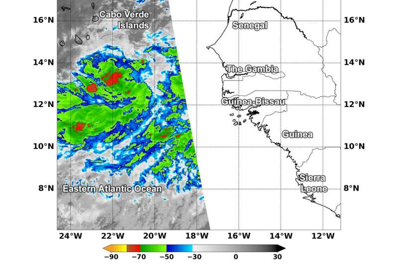
NASA finds some strong storms in Atlantic's potential tropical cyclone 6

The Northern Atlantic Ocean has only seen five storms so far this hurricane season and satellite data indicates a potential sixth tropical cyclone is forming in the far eastern Atlantic Ocean.
Because of the potential for a tropical cyclone to develop, a Tropical Storm Warning is in effect for Santiago, Fogo and Brava.
Infrared satellite imagery provides temperature data, and when NASA's Aqua satellite passed over the low pressure area east-southeast of the Cabo Verde Islands, the coldest cloud tops appeared fragmented in four areas,
Cloud top temperatures determine strength of the thunderstorms that make up a tropical cyclone. The colder the cloud top, the stronger the uplift in the storm that helps thunderstorm development. Basically, infrared data helps determine where the most powerful storms are within a tropical cyclone.
The Moderate Resolution Imaging Spectroradiometer or MODIS instrument aboard Aqua provided that infrared data on Aug. 30 at 11:25 a.m. EDT (1525 UTC). MODIS data showed the strongest thunderstorms were north and southwest of the center of circulation. They were as cold as or colder than minus 70 degrees Fahrenheit (minus 56.6 degrees Celsius). NASA research indicates very cold cloud tops with the potential to generate very heavy rainfall.
The NHC noted that the developing system could produce total rain accumulations of 4 to 8 inches across the southern Cabo Verde Islands. These rains could produce life-threatening flash floods.
At 2 p.m. EDT (1800 UTC) on Aug. 30, the National Hurricane Center or NHC said the disturbance was centered near latitude 12.9 degrees north and longitude 19.0 degrees west. The system is moving toward the west near 12 mph (19 km/h), and this general motion with a gradual turn toward the west-northwest is expected to continue during the next few days. On the forecast track, the disturbance is expected to move near or over the southern Cabo Verde Islands on Friday, Aug. 31.
Maximum sustained winds are near 30 mph (45 kph) with higher gusts. Some strengthening is forecast during the next 48 hours, and the disturbance is expected to become a tropical storm during the next day or so.
NHC said "Environmental conditions are favorable for the system to become a tropical cyclone tonight or Friday"
Provided by NASA's Goddard Space Flight Center


