NASA sees Hurricane Miriam tracking over the open Central Pacific

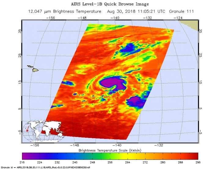
When NASA's Aqua satellite passed over Hurricane Miriam, it was moving to the northwest and was no threat to land areas in the Central Pacific Ocean. Aqua took a look at the storm in infrared light that provided temperature data to reveal the location of the most powerful thunderstorms that make up the tropical cyclone.
NASA's Aqua satellite passed over Miriam on Aug.30 at 7:05 a.m. EDT (1105 UTC) the Atmospheric Infrared Sounder or AIRS instrument analyzed the storm in infrared light which provides temperature information. Temperature is important when trying to understand how strong storms can be. The higher the cloud tops, the colder and the stronger they are.
AIRS saw coldest cloud top temperatures around the center and in a large band of thunderstorms extending east and south of the center. In both of those areas, cloud top temperatures were as cold as minus 63 degrees Fahrenheit (minus 53 degrees Celsius). Since the AIRS overpass, however, cloud tops have been warming in the southeast. There is also some drier air working its way into the circulation.
On Aug. 30 at 11 a.m. EDT (5 a.m. HST/1500 UTC) NOAA's Central Pacific Hurricane Center or CPHC noted the center of Hurricane Miriam was located near latitude 15.3 degrees north and longitude 141.6 degrees west. That's about 940 miles (1,510 km) east-southeast of Hilo, Hawaii.
Miriam is moving toward the northwest near 8 mph (13 kph). A turn toward the north is expected later today, with this motion continuing through Friday night. A turn toward the northwest is expected on Saturday.
Maximum sustained winds are near 80 mph (130 kph) with higher gusts. Some additional intensification is expected today, followed by fairly rapid weakening Friday through Saturday night, Sept. 1. Hurricane Miriam heading northwestward across the Central Pacific and is expected to remain far away from land.
Provided by NASA's Goddard Space Flight Center


