Researchers develop new capability to evaluate human-driven change in Eastern U.S. streams

A stream classification system developed by researchers at the Department of Energy's Oak Ridge National Laboratory can help assess physical changes to United States streams and rivers from human influences and aid in more effective management of water resources.
The novel framework, published in PLOS ONE, is designed to incorporate physical habitat features important to stream ecology, including size, gradient, temperature, hydrology, valley confinement and substrate, into a composite map of stream diversity. An initial focus on the Eastern U.S. estimated over 5,000 stream types, most of which are rare and as many as one third affected by human impacts.
The ORNL-led team used geospatial datasets, remotely sensed information and predictive analysis to map approximately one million stream reaches across the Eastern U.S. At a stream-reach scale, the project is the first significant effort to produce a geospatial inventory of stream types at this scope.
The work, funded by DOE's Water Power Technologies Office, aims to provide industry, regulators and stakeholders with scientific insights on developing and managing hydropower systems effectively and mitigating the environmental impacts of energy production.
Until now, stream classification has been largely regional, focused on evaluations of discrete stream segments rather than the entire length of branching river networks. The new classification system is designed to capture a connected landscape, wherein upstream water use influences downstream habitats supporting various ecosystems.
"This kind of holistic view of stream environments, specifically stream diversity, over a large spatial area has not been available and is essential to improving our understanding of natural and altered stream conditions," said lead coauthor Ryan McManamay of ORNL's Environmental Sciences Division and the Urban Dynamics Institute.
In their study of the Eastern U.S., researchers identified common and rare stream types and the extent to which these have been affected by human activities, such as urbanization, agriculture and energy production.
Combinations of the physical features yielded an estimated 1,521 total stream types. Out of 1.5 million total stream kilometers, 95 percent of the stream length comprised fewer than 30 percent of types. The finding suggests most stream types in the Eastern U.S. are rare.
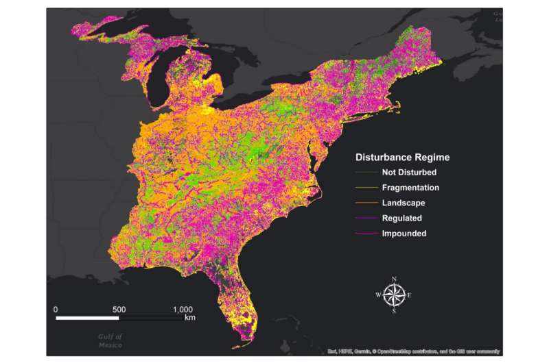
Researchers compared land cover datasets with stream typologies to examine human-driven changes to natural stream environments. Introducing dams, reservoirs, agriculture and urban structures into riverscapes can alter streams' physical features with adverse impacts to water resources and aquatic ecosystems. According to the coauthors, nearly 70 percent of streams in the Eastern U.S. "are either impounded, regulated, highly fragmented, or have significant landscape disturbances." Thirty-two percent of stream types had at least 95 percent of their lengths impacted in some way, meaning 492 of 1,521 classes have no natural representation in the landscape. In other words, a third of stream diversity in the region has been lost. Results also showed rare stream types, especially large river systems, are more likely to be affected by human activity.
The team notes that the stream classification framework can be used to prioritize areas for conservation or restoration, while also assisting in mitigation planning. As a case study, researchers identified rare, highly altered stream types and targeted approximately 30,000 km of stream reaches across the Eastern U.S., or 1,463 km per state, for restoration projects. The study also showcased how stream classes can be used to identify shared properties among streams, so as to find reference streams or case studies to guide water management decisions.
A comprehensive view of streams' physical diversity holds practical applications for industries, utilities and their stakeholders. Stream classification supports water management by informing environmental regulations, mitigation strategies and future development.
"Our system is flexible," said McManamay, "and can be combined with other high-resolution datasets to answer a range of big-picture questions about stream habitats and human-driven impacts to physical and biodiversity."
More information: Ryan A. McManamay et al. A stream classification system to explore the physical habitat diversity and anthropogenic impacts in riverscapes of the eastern United States, PLOS ONE (2018). DOI: 10.1371/journal.pone.0198439
Journal information: PLoS ONE
Provided by Oak Ridge National Laboratory


