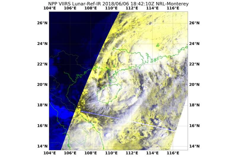
NASA sees Ewiniar slide back into South China Sea and strengthen

Tropical Cyclone Ewiniar made landfall on mainland China and as the center of circulation has moved back into the South China Sea and reorganized, NASA-NOAA's Suomi NPP provided a look at the storm.
On June 6 at 2:42 p.m. EDT (1842 UTC) the Visible Infrared Imaging Radiometer Suite (VIIRS) instrument aboard NASA-NOAA's Suomi NPP satellite captured an infrared image of Ewiniar. VIIRS is a scanning radiometer That means as the satellite orbits the Earth, VIIRS scans a swath that is ~3040 km wide (the cross-track direction).
The VIIRS image showed that Ewiniar's center was just northeast of Hainan Island, China. Bands of thunderstorms from Ewiniar's southwestern quadrant blanketed Hainan Island.
On June 6 at 1500 UTC (11 a.m. EDT) Ewiniar regained strength in the warm waters of the South China Sea, and has for the second time become a tropical storm. Maximum sustained winds were near 40 mph (35 knots/65 kph).
Tropical Storm Ewiniar's center was located near 21.8 degrees south latitude and 112.0 degrees east longitude. That's approximately 129 nautical miles west-southwest of Hong Kong, China. Ewiniar was moving to the north-northeast at 8 mph (7 knots/13 kph).
The China Meteorological Administration (CMA) continued the "Blue Warning of Typhoon" and a "Yellow Warning for Rainstorm" at 6:00 a.m. (local time) on June 7. CMA's Blue Warning said " From June 7 to 8, the scale 6-7 gale will blow northwestern South China Sea, Qiongzhou Strait, eastern and northern coast of Hainan Island, central-western Guangdong and Pearl River Estuary. Northwestern South China Sea and southwestern coast of Guangdong will see scale 8-9 gale or scale 10-11 gust. Heavy rain to rainstorm with severe convective weather will hit northern Hainan Island, central-western Guangdong, eastern Guangdong, southeastern Hunan and southwestern Jiangxi. Southern coast of Guangdong will see extreme rainstorm. (June 7)." For updated forecasts from CMA, visit: http://www.cma.gov.cn.
The Joint Typhoon Warning Center or JTWC noted that Ewiniar is expected to make landfall later today in southeastern China's mainland and will dissipate quickly.
Provided by NASA's Goddard Space Flight Center


