NASA analyzes Tropical Cyclone Eliakim's rainfall, wind shear now affecting storm

Tropical Cyclone Eliakim soaked the eastern coast of Madagascar as it moved in a southerly path. NASA analyzed that rainfall using data from the Global Precipitation Measurement mission or GPM core satellite. Another NASA satellite provided a current look at the storm that revealed wind shear was taking a toll on the storm.
Tropical cyclone Eliakim's heavy rainfall caused flooding and landslides over eastern Madagascar that resulted in at least seven deaths. Eliakim came less than two weeks after another tropical cyclone called Dumazile passed close to Madagascar. Eliakim maintained but didn't exceed tropical storm intensity as it battered Madagascar. Eliakim's slower movement as it passed over the island nation caused continuous heavy rainfall over northeastern Madagascar. Tropical cyclone Eliakim has now moved back into the Indian Ocean and is moving toward the southeast and away from Madagascar.
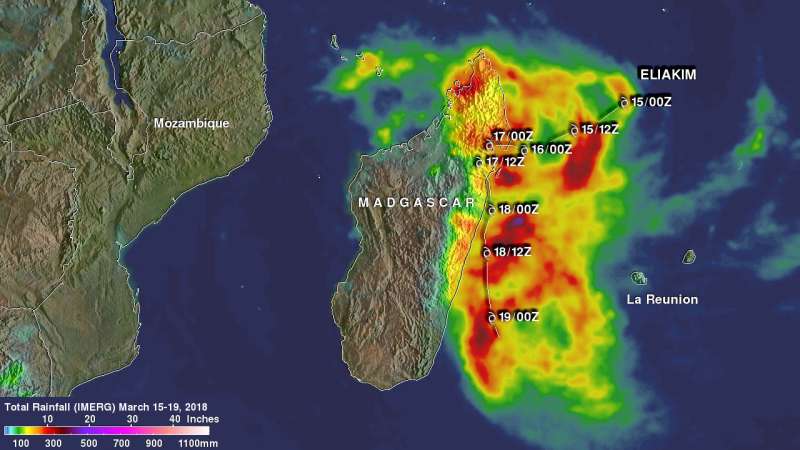
A rainfall accumulation analysis at NASA's Goddard Space Flight Center in Greenbelt, Maryland was derived from NASA's Integrated Multi-satellitE Retrievals data (IMERG). IMERG data are used to calculate estimates of precipitation from a combination of space-borne passive microwave sensors, including the GMI microwave sensor onboard the GPM satellite, and geostationary IR (infrared) data. The analysis shows IMERG rainfall accumulation estimates during the period from March 15 to 19, 2018.
Tropical cyclone Eliakim drenched Madagascar as it formed in the Indian Ocean, moved slowly over northeastern Madagascar and then moved back into the Indian Ocean. The tropical cyclone's clockwise rotation caused an onshore flow of moisture from the Indian Ocean onto eastern Madagascar during much of the period.
Rainfall total estimates of over 300 mm (11.8 inches) were common along Eliakim's path. IMERG data indicated that over 500 mm (19.7 inches) of rain fell in some areas close to Madagascar's coast
The GPM core observatory satellite had a good view of tropical cyclone Eliakim on March 18, 2018 at 0210 UTC (March 17 at 10:10 p.m. EDT). GPM's Microwave Imager (GMI) and Dual Frequency Precipitation Radar (DPR) data showed that rainfall was still moving over Madagascar but the bulk of ELIAKIM's heavy rainfall was occurring in the Indian Ocean. GMI showed that rain was falling at a rate of over 47 mm (1.9 inches) per hour in one of these showers. GPM is a joint mission between NASA and the Japanese Aerospace Exploration Agency.

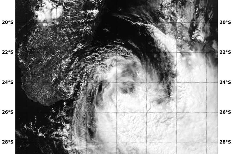
After Eliakim moved off the coast of Madagascar it began running into wind shear that was weakening the storm. The Moderate Resolution Imaging Spectroradiometer or MODIS instrument that flies aboard Aqua provided a visible-light image of the tropical cyclone on March 19 at 6:45 a.m. EST (1045 UTC). The image showed what looked like wispy clouds north of the low-level circulation center. The bulk of clouds were being pushed to the south and southeast of the center as a result of northwesterly vertical wind shear.
At 11 a.m. EDT (1500 UTC) on March 19, 2018, Tropical Cyclone Eliakim was located approximately 350 nautical miles southwest of St. Denis, La Reunion Island. It was centered near 25.2 degrees south latitude and 51.1 degrees east longitude. Eliakim was moving to the south-southeast at 16 mph (14 knots/26 kph). Maximum sustained winds were near 52 mph (45 knots/74 kph).
The Joint Typhoon Warning Center noted "the storm will continue to track south-southeastward for the remainder of the forecast, remain at 40 to 45 knots," begin extratropical transition by March 20 at 11 a.m. EDT and complete it in two days.
Provided by NASA's Goddard Space Flight Center


