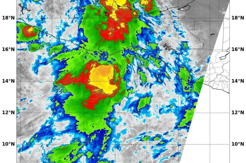
On Oct. 4, NASA-NOAA's Suomi NPP satellite showed some strong storms around Tropical Storm Ramon's center of circulation where cloud top temperatures were as cold as (yellow) minus 80 degrees Fahrenheit (minus 62.2 degrees Celsius), indicating strong thunderstorms with potential for heavy rainfall. Credit: NOAA/NASA/NRL
NASA-NOAA's Suomi NPP satellite looked at Tropical Storm Ramon in infrared light, revealing powerful storms around the center. Ramon formed close to the southwestern coast of Mexico and has already generated a tropical storm watch.
The government of Mexico has issued a Tropical Storm Watch from Puerto Angel to Acapulco.
On Oct. 4 at 4:30 a.m. EDT (0830 UTC) the Visible Infrared Imaging Radiometer Suite (VIIRS) instrument aboard Suomi NPP analyzed Tropical Storm Ramon in infrared light. Infrared light provides temperature information. The infrared data showed some strong storms around the center of circulation where cloud top temperatures were as cold as minus 80 degrees Fahrenheit (minus 62.2 degrees Celsius), indicating strong thunderstorms with potential for heavy rainfall.
At 10 a.m. CDT/11 a.m. EDT (1500 UTC), the National Hurricane Center (NHC) said the center of Tropical Storm Ramon was located near 14.9 degrees north latitude and 96.5 degrees west longitude.
Ramon was moving toward the west-northwest near 7 mph (11 kph) and a generally westward motion with some increase in forward speed is expected over the next couple of days. Maximum sustained winds are near 45 mph (75 kph) with higher gusts. The NHC said "Only slight strengthening is forecast during the next 48 hours."
Ramon is a small tropical storm. Tropical-storm-force winds extend outward up to 35 miles (55 km) from the center. The estimated minimum central pressure is 1002 millibars.
On the forecast track, the center of Ramon is expected to move parallel to, but remain offshore of, the coast of southern Mexico.
Provided by NASA's Goddard Space Flight Center


