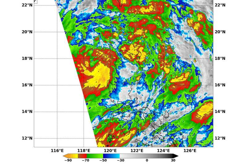
Image: Tropical Storm Khanun (South China Sea)

NASA's Aqua satellite provided an infrared view of Tropical Storm Khanun that showed strongest thunderstorms southeast of the center of circulation.
Khanun developed from a depression on Oct. 12 in the eastern part of the South China Sea, about 262 nautical miles northeast of Manila, Philippines. The twenty-fourth tropical depression of the northwestern Pacific Ocean strengthened into a tropical storm by 11 a.m. EDT (1500 UTC) on Oct. 12.
On Oct. 13 at 12:50 a.m. EDT (0450 UTC) the Moderate Resolution Imaging Spectroradiometer or MODIS instrument aboard NASA's Aqua satellite read cloud top temperatures in Tropical Storm Khanun as it moved through the northwestern Pacific Ocean.
Infrared satellite imagery showed the strongest thunderstorms and convection (rising air that forms the thunderstorms that make up the tropical cyclone) associated with the system were southeast of the center. The MODIS data showed cloud top temperatures south of the center were between minus 70 degrees and minus 80 degrees Fahrenheit (minus 56.6 degrees and minus 62.2 degrees Celsius).
The infrared temperature data enables scientists to learn where the strongest storms are located within a typhoon. The colder the cloud tops, the higher they are in the troposphere and the stronger the storms. NASA data has shown that cloud tops that are at least as cold as minus 63 degrees Fahrenheit (minus 53 degrees Celsius) have the ability to generate heavy rainfall.
The Joint Typhoon Warning Center noted that "Animated enhanced infrared satellite imagery shows a low-level circulation center with deep convective banding wrapping tightly into a well-defined center. A microwave image revealed an eye feature located to the west of Luzon, Philippines."
At 11 a.m. EDT (1500 UTC) Khanun's maximum sustained winds were near 63.3 mph (55 knots/102 kph). Khanun was moving to the west-southwest at 9 knots (10.3 mph/16.6 kph). It was centered near 17.1 degrees north latitude and 118.4 degrees east longitude about 607 nautical miles east of Da Nang, Vietnam.
Khanun is forecast to move west through the northern South China Sea and strengthen to typhoon strength as it nears Hainan Island, China before making a final landfall in northern Vietnam on Oct. 16.
Provided by NASA


