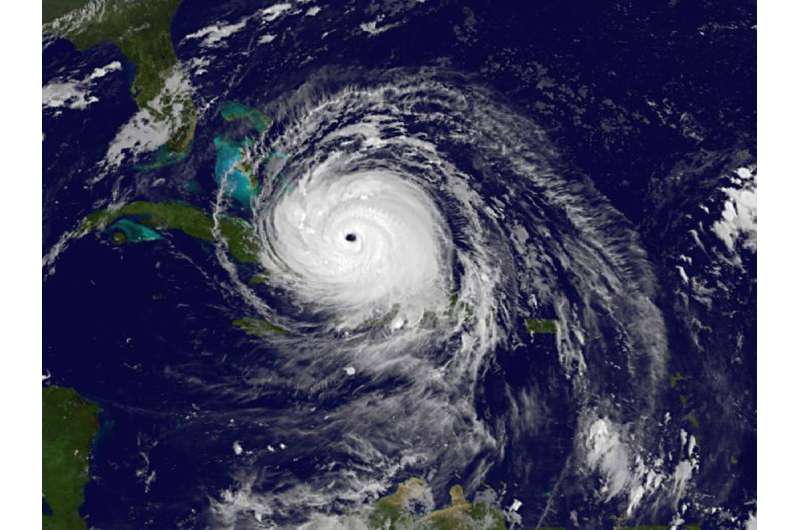
NOAA's GOES East satellite captured this infrared image of Hurricane Irma in the Bahamas at 4:45 a.m. EDT. Credit: NASA/NOAA GOES Project
NASA's fleet of satellites have been continually providing forecasters with data on Hurricane Irma. NASA-NOAA's Suomi NPP satellite provided a look at the wide-eye of Irma and if you think about the area of maximum sustained winds around the eye, it's similar to a wide F2 tornado.
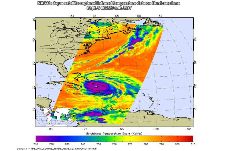
The Atmospheric Infrared Sounder or AIRS instrument aboard NASA's Aqua satellite captured infrared temperature data on Hurricane Irma on Sept. 8 at 2:29 a.m. EDT (0629 UTC). The image showed very cold cloud top temperatures colder than minus 63 degrees Fahrenheit (minus 53 degrees Celsius) in the storm, stretching over Hispaniola, eastern Cuba and the Bahamas. NASA research has shown that cloud tops that cold are high in the troposphere and have the potential to generate heavy rainfall.
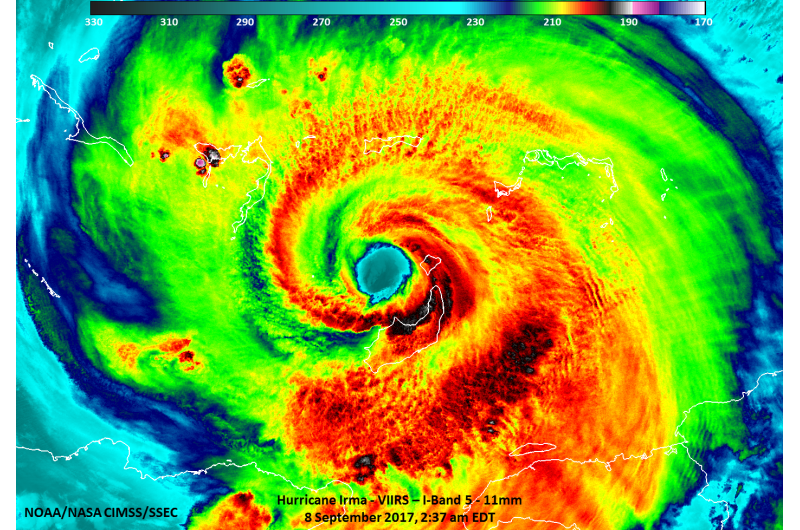
The Visible Infrared Imaging Radiometer Suite (VIIRS) instrument aboard NASA-NOAA's Suomi NPP satellite provided an infrared look at the thunderstorms throughout Irma on Sept. 9 at 2:39 a.m. EDT. The VIIRS image showed the well-defined eye of Irma with strong thunderstorms around the eye which is indicative of an intense tropical system. Strongest thunderstorms with coldest cloud tops were as cold as 195 Kelvin (minus 78.1 degrees Celsius/minus 108.7 degrees Fahrenheit).
NOAA's GOES East satellite captured an infrared image of Hurricane Irma in the Bahamas at 4:45 a.m. EDT that showed a clear eye and a symmetrical, powerful Category 4 hurricane. NOAA manages the GOES series of satellites and the NASA/NOAA GOES Project at NASA's Goddard Space Flight Center in Greenbelt, Maryland produces images and animations from that data.
NASA uses a constellation of domestic and international satellites to better understand the rainfall accumulations of Irma, wind speeds, and impacts as the storm makes landfall.
Irma's Area of Maximum Sustained Winds Like a Wide Tornado
The National Hurricane Center (NHC) noted that hurricane-force winds extend outward up to 70 miles (110 km) from the center and tropical-storm-force winds extend outward up to 185 miles (295 km). Maximum sustained winds are near 150 mph (240 kph) with higher gusts.
Scott Braun, research meteorologist at NASA Goddard said that "Hurricane force winds mean greater than 64 knots and tropical storm force winds are greater than 34 knots. The actual diameter of hurricane force winds is 120 miles. However, that is just for greater than 64 knots. The area with greater than 150 mph wind will be smaller."
In this Suomi NPP satellite infrared image from Sept. 9 at 2:39 a.m. EDT, the well-defined eye of Irma is visible with convection around the eye which is indicative of an intense tropical system. Strongest thunderstorms with coldest cloud tops (black) were as cold as 195 Kelvin. Credit: NASA/NOAA/UWM-CIMSS, William Straka
The area of maximum sustained winds near 150 mph fluctuate but on average have been about 25 miles out from the eye. Using that as average, if you think of the power of these rotating winds compared to a tornado, it would be would be similar to a 50-mile wide F2 tornado on the Fujita Scale (with maximum winds between 113 and 157 mph).
Warnings and Watches on Sept. 9
At 11 a.m. EDT on Sept. 9, the National Hurricane Center (NHC) had a Storm Surge Warning is in effect for Sebastian Inlet southward around the Florida peninsula to Venice, Florida, and the Florida Keys. A Storm Surge Watch is in effect from North of Sebastian Inlet to Ponce Inlet.
A Hurricane Warning is in effect for Jupiter Inlet southward around the Florida peninsula to Bonita Beach, Florida; the Florida Keys; Lake Okeechobee; Florida Bay; the Southeastern Bahamas and the Turks and Caicos Islands; the Cuban provinces of Camaguey, Ciego de Avila, Sancti Spiritus, and Villa Clara; the Central Bahamas and the Northwestern Bahamas.
A Hurricane Watch is in effect from north of Jupiter Inlet to the Flagler/Volusia County Line; north of Bonita Beach to Anclote River and the Cuban provinces of Guantanamo, Holguin, Las Tunas and Matanzas. A Tropical Storm Warning is in effect for the Cuban provinces of Guantanamo, Holguin, and Las Tunas.
Irma's Location at 11 a.m. EDT on Sept. 8
At 11 a.m. EDT (1500 UTC), the NHC said the distinct eye of Hurricane Irma was located near 22.0 degrees north latitude and 75.3 degrees west longitude. That's 405 miles (655 km) southeast of Miami, Florida.
Irma was moving toward the west-northwest near 14 mph (22 kph), and this motion is expected to continue for the next day or so with a decrease in forward speed. A turn toward the northwest is expected by late Saturday, Sept. 9. Maximum sustained winds are near 150 mph (240 kph) with higher gusts. Irma is a category 4 hurricane on the Saffir-Simpson Hurricane Wind Scale. Some fluctuations in intensity are likely during the next day or two, but Irma is forecast to remain a powerful category 4 hurricane as it approaches Florida.
NASA's Aqua satellite captured infrared temperature data on Hurricane Irma on Sept. 8 at 2:29 a.m. EDT (0629 UTC). The image showed very cold cloud top temperatures colder than minus 63 degrees Fahrenheit (minus 53 degrees Celsius) in the storm, stretching over Hispaniola, eastern Cuba and the Bahamas. Credit: NASA JPL/Ed Olsen
Hurricane-force winds extend outward up to 70 miles (110 km) from the center and tropical-storm-force winds extend outward up to 185 miles (295 km). The latest minimum central pressure reported by both Air Force and NOAA Hurricane Hunter planes was 927 millibars.
Key Cautions to Remember
NHC noted several key cautions to keep in mind:
1. Irma is an extremely dangerous Category 4 hurricane and will continue to bring life-threatening wind, storm surge, and rainfall hazards to the Bahamas through Saturday.
2. Irma is likely to make landfall in Florida as a dangerous major hurricane, and will bring life-threatening wind impacts to much of the state regardless of the exact track of the center.
3. There is the danger of life-threatening storm surge inundation in southern Florida and the Florida Keys during the next 36 hours, where a Storm Surge Warning is in effect.
4. Irma is expected to produce very heavy rain and inland flooding. Total rain accumulations of 4 to 12 inches, with isolated amounts of 20 inches are expected over the Florida peninsula Saturday through Monday.
On the NHC forecast track, the eye of Irma should move near the north coast of Cuba and the central Bahamas today and Saturday, and be near the Florida Keys and the southern Florida Peninsula Sunday morning, Sept. 10.
For updates on Irma visit: http://www.nhc.noaa.gov
Provided by NASA's Goddard Space Flight Center


