Irma is looking more and more Tampa-bound, forecasters say (Update)
")
Hurricane Irma is making its slow fateful right turn that will put it on a collision course with Florida's west coast Sunday as forecasts are locking in on a path that includes the Keys, southwestern Florida and the Tampa Bay region.
"It's just starting to happen,'" National Hurricane Center meteorologist Dennis Feltgen said Friday afternoon. "The center has cleared the Cuban coast, it's entering the Florida Straits."
And as it is doing so, the storm that had fallen to a Category 3 with 125 mph (20 kph) winds, is already showing signs of regaining its previous powerhouse strength, getting better organized, Feltgen said. The warm water in the Florida Straits is flirting with 90 degree temperatures and is deep, essentially a buffet for a hurricane.
"The hurricane warnings are for the entire peninsula and west to Panama City," said Ryan Maue, a meteorologist at the private firm WeatherBell Analytics. "Only 70 miles of the panhandle is not under a hurricane warning ... That's how massive the hurricane is."
It's about 350 to 400 miles wide, Feltgen said. So even though Irma's eye is heading west, that doesn't mean the Miami area is in the clear. Some 20 inches of rain and a storm are expected there as well.
The latest hurricane center forecast—which still can change a bit and has a margin of error of dozens of miles—projects Irma's potent eye to wash ashore three times in Florida: The Keys, around Fort Myers inland to Tampa and then out to open Gulf of Mexico waters briefly before returning inland, north of Homosassa Springs.
")
The forecasts even have it at hurricane strength well into Georgia on Monday.
For decades, disaster officials and meteorologists have put the Tampa region as one of their worst-case scenarios, along with Miami, New Orleans, Houston and New York. The other four cities have been hit in the last 25 years but Tampa has not been hit by a major hurricane since 1921 when its population was about 10,000, Feltgen said. Now it has around 3 million people.
"It's certainly one of those metropolitan areas where we have one of the greatest concerns, particularly with storm surge, particularly with inexperience," Feltgen said.
This track's turn into Florida is being caused because a high pressure system to the north is weakening. That allows winds from the north to essentially pull the hurricane north toward Florida, said Jeff Masters, meteorology director at the private service Weather Underground. The turn had been long forecast, but had it happened earlier, it would have aimed more at the east side of Florida.
")
Colorado State University hurricane researcher Phil Klotzbach worries about storm surge on the west coast, calling it "surge central."
"That honestly more than the wind is going to be the story," he said.
Klotzbach looked at hurricane center storm surge maps splashed with bright yellows and reds and said Naples made him especially nervous.
"Look at Naples, the entire town of Naples is underwater," Klotzbach said. "That is horrible. God that looks awful."
")
The hurricane center forecasts 10 to 15 feet (3 to 4.6 meters) of storm surge in extreme southwestern Florida, an area that includes Fort Myers and Naples. Experts say the area from Ana Maria Island to Captiva Island will get about 6 to 10 feet (1.8 to 3 meters), with the Tampa Bay region getting about 5 to 8 feet (1.5 to 2.4 meters) further north. Clearwater Beach to the middle of the Florida Panhandle, surge should be 4 to 6 feet (1.2 to 1.8 meters).
The Miami area is also forecast to get 4 to 6 feet of surge. From North Miami Beach to Fernandina Beach surge 2 to 4 feet (0.6 to 1.2 meters) of surge is expected, with 4 to 6 feet from Fernandina Beach into South Carolina.
High wind, tornadoes and heavy rainfall of up to 20 inches (0.5 meters) are forecast for most of Florida.
It's a few days out and it can still change, but forecasters worry that the remnants of Irma will stall out in the Tennessee Valley and bring lots of rain and potential flooding.
")
If the forecast track doesn't change—it is likely to shift—the Nashville area will end up getting the remnants of both Harvey and Irma.
___
HURRICANE NEWSLETTER - Get the best of the AP's all-formats reporting on Irma and Harvey in your inbox: apne.ws/ahYQGtb
-
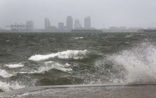
The winds and sea are whipped up off of the Rickenbacker Causeway in Miami as Hurricane Irma approaches on Saturday, Sept. 9, 2017. ( Mike Stocker/South Florida Sun-Sentinel via AP) -
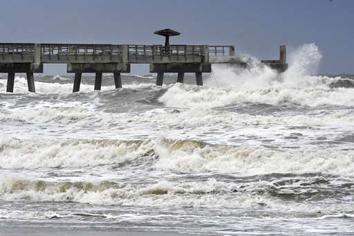
Waves crash on the Jacksonville Beach Fishing Pier in Jacksonville Beach, Fla., as Hurricane Irma approaches Florida on Saturday Sept. 9, 2017. (Bob Mack/The Florida Times-Union via AP) -
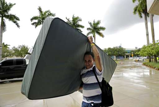
Hector Padron carries his mattress as evacuees are moved to another building with more bathrooms while sheltering at Florida International University ahead of Hurricane Irma in Miami, Saturday, Sept. 9, 2017. (AP Photo/David Goldman)
© 2017 The Associated Press. All rights reserved.


