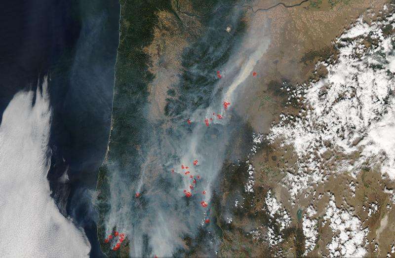
Credit: NASA image courtesy Jeff Schmaltz LANCE/EOSDIS MODIS Rapid Response Team, GSFC
Fires meander up and down the state of Oregon mostly through the Cascade Mountains in this NASA Aqua satellite image taken on Aug. 28, 2017. The fires were mostly started by lightning strikes and Inciweb is tracking 20 different fires of varied sizes. The largest fire being tracked is the Chetco Bar Fire which is located in the Kalmiopsis Wilderness, roughly six air miles west of Pearsoll Peak and north of the Chetco River. It has spread from its initial 1/4 acre size when it began on July 12, 2017 to its current size of 117,669. The fire is actually burning in old fire scars from previous fires in 1997 and 2002. It has spread to areas previously unburned and the combination of down, dead fuels with a newly cured grass makes the terrain quite hazardous for firefighters. Hot, dry conditions with moderate winds persist in the area making firefighting hazardous and fire spread more likely.
The second largest fire in Oregon is the Nena Springs fire which is located near Warm Springs, Oregon. This fire, unlike most of the others, was human caused and is still under investigation. It began on August 08. At present the fire is almost 75% contained at present (at 68,135 acres) which is positive news. Firefighters do not expect the footprint to get any larger. Surface fire is smoldering in areas. Mop-up work requires attention to ensure the fire does not smolder outside of contained areas. A smaller force of firefighters will remain at Warm Springs to complete the work left yet to do.
The third largest fire is the Cinder Butte fire but it is mostly contained at 90%. The rest of the fires are below 22,000 acres.
This Aqua satellite natural-color image was captured by the Moderate Resolution Imaging Spectroradiometer, MODIS, instrument on the satellite. Actively burning areas, detected by MODIS's thermal bands, are outlined in red.
Provided by NASA


