NASA sees Tropical Storm Harvey moving back into the Gulf

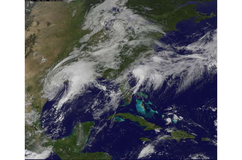
On Monday, Aug. 28 at 7 a.m. CDT the National Hurricane Center said the center of Harvey is emerging into the Gulf of Mexico. A NASA animation of imagery from NOAA's GOES East satellite shows Harvey as it lingered over southeastern Texas over the weekend of Aug. 26 and 27 and moving back toward the Gulf of Mexico on Aug. 28.
The National Hurricane Center noted "life-threatening flooding continues over southeastern Texas." NHC stressed that people should never attempt to travel into flooded roadways.
Taking Harvey's Temperature
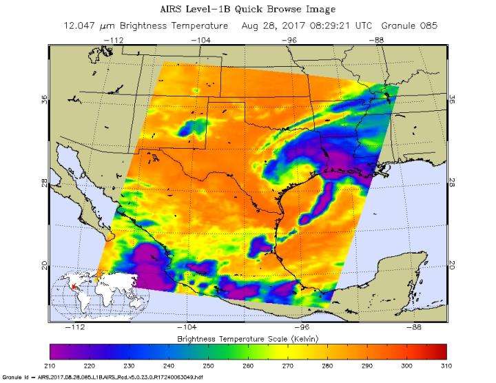
The Atmospheric Infrared or AIRS instrument aboard NASA's Aqua satellite captured infrared data on Harvey on Aug. 28 at 4:29 a.m. EDT (0829 UTC). Infrared data provides temperature information to scientists. The image showed that the coldest cloud tops and strongest storms stretched from southeastern Texas to Louisiana and into the Gulf of Mexico. Cloud top temperatures in those areas were colder than minus 63 degrees Fahrenheit (minus 53 degrees Celsius). NASA research has shown that storms with cloud tops that cold, reached high into the troposphere and had the ability to generate heavy rain.
Satellite Animation Shows Harvey's Movement
An animation of NOAA's GOES East satellite visible and infrared imagery from 9:15 a.m. CDT (1315 UTC), Aug. 26 to 9:30 a.m. CDT (1330 UTC), Aug. 28 was created at NASA's Goddard Space Flight Center in Greenbelt, Maryland. The animation showed Hurricane Harvey transitioning to a tropical storm at 1 p.m. CDT (1700 UTC) on Aug. 26 and slowly emerging in the Gulf of Mexico on Aug. 28.
NOAA manages the GOES series of satellites, and NASA uses the satellite data to create images and animations. The animation was created by the NASA/NOAA GOES Project at NASA's Goddard Space Flight Center in Greenbelt, Maryland.
Heavy Rainfall and Severe Flooding
NHC noted at 7 a.m. CDT on Monday, Aug. 28 "Harvey is expected to produce additional rainfall accumulations of 15 to 25 inches through Friday over the upper Texas coast and into southwestern Louisiana. Isolated storm totals may reach 50 inches over the upper Texas coast, including the Houston/Galveston metropolitan area. These rains are currently producing catastrophic and life-threatening flooding, and flash flood emergencies are in effect for portions of southeastern Texas.

Elsewhere, Harvey is expected to produce total rain accumulations of 5 to 15 inches farther south into the middle Texas coast, farther west toward the Texas Hill Country, and farther east across south-central Louisiana.
National Weather Service Links for Harvey flooding and rainfall information:
NWS Houston, NWS Lake Charles, NWS Corpus Christi, NWS Austin/San Antonio, Weather Prediction Center
Harvey's Location at 7 a.m. CDT on Aug. 28
NOAA's National Hurricane Center said at 7 a.m. CDT (8 a.m. EDT) (1200 UTC), the center of Tropical Storm Harvey was located near 28.6 degrees north latitude and 96.1 degrees west longitude. That's about 25 miles (40 km) northeast of Port O'Connor, Texas. Harvey was moving toward the southeast near 3 mph (6 kph) and a slow southeastward motion is expected today. A slow northeastward motion is expected to begin on Tuesday. The center of Harvey is emerging off of the middle Texas coast, and it is expected to remain just offshore through Tuesday.
Maximum sustained winds are near 40 mph (65 kph) with higher gusts. Slight re-strengthening is possible later today and Tuesday, Aug. 29. The minimum central pressure estimated from surface observations along the Texas coast is 997 millibars.
Tropical Storm Warnings and Flooding Continues
On Aug. 28, a Tropical Storm Warning was in effect for Mesquite Bay to High Island, Texas. The NHC said "catastrophic and life-threatening flooding continues in southeastern Texas, and flash flood emergencies are in effect for portions of this area."
Interests elsewhere along the upper Texas coast and in southwestern Louisiana should continue to monitor the progress of Harvey.
Provided by NASA's Goddard Space Flight Center


