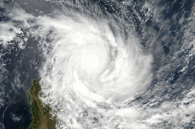
On March 7 at 10:24 UTC (5:24 a.m. EST) NASA-NOAA's Suomi NPP satellite provided a visible image of Enawo just after landfall in northeastern Madagascar. Credit: NOAA/NASA Goddard MODIS Rapid Response
Tropical Cyclone Enawo was battering the northeastern region of Madagascar when NASA-NOAA's Suomi NPP satellite passed overhead on March 7. Enawo strengthened to the equivalent of a Category 4 or major hurricane and made landfall.
On March 7 at 10:24 UTC (5:24 a.m. EST) the Visible Infrared Imaging Radiometer Suite (VIIRS) instrument aboard NASA-NOAA's Suomi NPP satellite provided a visible image of Enawo. The VIIRS image showed the center of circulation near the northeastern coast of Madagascar and outer bands of thunderstorms stretched to the middle of the island nation. The VIIRS visible imagery showed clouds had filled the top of the 20 nautical-mile-wide eye, but the eye was still seen in multispectral satellite imagery. Enawo's center of circulation was bordered by a thick band of thunderstorms wrapping from the eastern to the southern quadrant, and another band from the southern quadrant wrapping into the western side of the storm.
The Joint Typhoon Warning Center noted that the system made landfall at 0800 UTC (3 a.m. EST) on March 7 at 14.6 degrees north latitude and 50.2 degrees east longitude, about half way between Sambava and Antalaha.
Warnings were posted throughout northern Madagascar and into the eastern and central portions of the country.
At 0900 UTC (4 a.m. EST) Enawo's maximum sustained winds had strengthened to 144 mph (125 knots/231 kph) making it a Category 4 hurricane on the Saffir-Simpson Wind Scale. Enawo was located near 14.7 degrees south latitude and 50.2 degrees east longitude. That's about 444 nautical miles northwest of St. Denis.
NOAA's National Hurricane Center noted that a Category 4 hurricane can have the following effects: Well-built framed homes can sustain severe damage with loss of most of the roof structure and/or some exterior walls. Most trees will be snapped or uprooted and power poles downed. Fallen trees and power poles will isolate residential areas. Power outages will last weeks to possibly months. Most of the area will be uninhabitable for weeks or months.
The Madagascar Meteorological Service has placed the following regions under alert:
A Red Alert or Alerte Rouge is in effect for: Sur Ambanja, Nosy-Be, Ambilobe, Vohimarina, Antsiranana, Andapa, Sambava, Antalaha, Mampikony, Bealanana, Antsohihy, Befandriana-Avaratra, Analalava, Mandritsara, Port-Berger, Tsaratanana, Marovoay, Ambato-Boina, Maevatanana, Mahajanga, Soanierana-Ivongo, Andilamena, Vavatenina, Ambatondrazaka, Amparafaravola, Vatomandry, Vohibinany, Fenoarivo-Atsinanana, Mananara-Avaratra, Maroantsetra, Sainte Marie, Toamasina.
A Yellow Alert or Alerte Jaune is in effect for: Sur Kandreho, Mitsinjo, Soalala, Anosibe-Anala, Moramanga, Antanambao-Manampotsy, Marolambo, Mahanoro, Fenoarivo-Afovoany, Antananarivo-Atsimondrano, Faratsiho, Andramasina, Antanifotsy, Soavinandriana, Miarinarivo, Tsiroanomandidy, Ambatolampy, Betafo, Antsirabe, Anjozorobe, Manjakandriana, Arivonimamo, Ankazobe, Ambohidratrimo, Antananarivo.
A Green Alert or Alerte Verte is in effect for: Sur Manandriana, Befotaka, Iakora, Fianarantsoa, Ikalamavony, Ivohibe, Vondrozo, Ihosy, Midongy-Atsimo, Vangaindrano, Farafangana, Vohipeno, Ikongo, Manakara-Atsimo, Mananjary, Ambohimahasoa, Nosy-Varika, Ifanadiana, Ambalavao, Fandriana, Ambositra, Ambatofinandrahana.
The Joint Typhoon Warning Center forecast track takes Enawo just west of Antananarivo and southward through the center of the country over the next couple of days.
Provided by NASA's Goddard Space Flight Center


