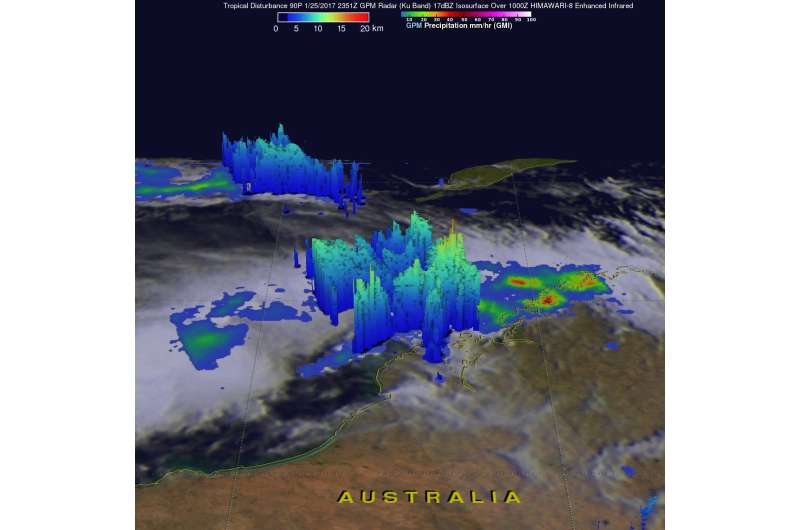
On January 25 at 6:51 p.m. EST (2351 UTC) the GPM satellite found rainfall rates in some of the bands of thunderstorms around the developing tropical cyclone were falling at a rate of almost 83 mm (3.3 inches) per hour as seen in this 3-D image. Credit: NASA/JAXA, Hal Pierce
A NASA satellite provided a look at heavy rainfall occurring in a tropical low pressure system as it was consolidating and strengthening into what became Tropical Storm 3S in Southwest Indian Ocean.
On January 26 the Joint Typhoon Warning Center (JTWC) warned that System 90P, a low pressure area moving westward over northwestern Australia would strengthen into a tropical cyclone and by January 27 it had become Tropical Cyclone 3S.
The warm waters of the Southern Indian Ocean and low vertical wind shear are providing a good environment for tropical cyclone development.
NASA and the Japan Aerospace Exploration Agency manage the Global Precipitation Measurement mission or GPM satellite, and GPM flew over northwestern Australia on January 25 at 6:51 p.m. EST (2351 UTC). GPM's Microwave Imager (GMI) and Dual-Frequency Precipitation Radar (DPR) measured precipitation within strong thunderstorms in the Indian Ocean northwest of the low's center of circulation. The satellite found that some of these bands of convective storms near northwest Australia's coast area were dropping rain at a rate of almost 83 mm (3.3 inches) per hour.
GPM's radar (Ku Band) sliced through powerful convective (rising air that condenses and forms thunderstorms) storms off Australia's coast and found that a few thunderstorm tops were reaching heights above 16 kilometers (9.9 miles).
On January 27, multispectral satellite imagery showed that Tropical Cyclone 03S continued to consolidate. When a storm consolidates it becomes stronger and more rounded. There were also shallow bands of thunderstorms that were wrapping into the large low-level center.
At 4 a.m. EST (0900 UTC) on January 27, 2017, the center of Tropical Cyclone 03S was located near 18.9 degrees south latitude and 118.4 degrees east longitude. Maximum sustained winds were near 40 mph (35 knots/65 kph)
On January 25 at 6:51 p.m. EST (2351 UTC) the GPM satellite found rainfall rates in some of the bands of thunderstorms around the developing tropical cyclone were falling at a rate of almost 83 mm (3.3 inches) per hour in this flyby animation. Credit: NASA/JAXA, Hal Pierce
Tropical cyclone 03s (three), located approximately 350 nautical miles northeast of Learmonth, Australia, has tracked west-southwestward at 18.4 mph (16 knots/29.6 kph) and is expected to continue on that track passing north of Learmonth on January 28 and dissipating in the Southern Indian Ocean on January 30.
The Australian Bureau of Meteorology (ABM) issued a Blue Alert for "people in parts of the Pilbara from Port Hedland (not including Port Hedland or South Hedland) to Ningaloo, including Barrow Island but not including Pannawonica. This includes the towns of Whim Creek, Wickham, Point Sampson, Roebourne, Karratha, Dampier, Onslow, MESA A and Exmouth."
ABM explained that the Blue Alert means damaging winds with gusts to 100 kph are possible over the Pilbara coast between Pardoo Roadhouse and Cape Preston later this evening. Damaging winds may extend to coastal parts between Cape Preston and Ningaloo on Saturday, January 28. Destructive winds with gusts to 130 kilometers per hour (81 mph) are possible on the southern side during Saturday, but are unlikely over Barrow Island and nearby islands unless the system tracks farther south and intensifies more quickly than forecast.
ABM also said "Squally thunderstorms are expected along the west Kimberley and Pilbara coasts during the remainder of Friday and Saturday. Heavy rainfall is likely across coastal parts of the west Kimberley and Pilbara. Flood Warnings are current for parts of the Kimberley and Pilbara. Tides will be higher than expected along the Pilbara coast on Friday night and Saturday."
More information: For further details please refer to www.bom.gov.au/wa/warnings/
Provided by NASA's Goddard Space Flight Center


