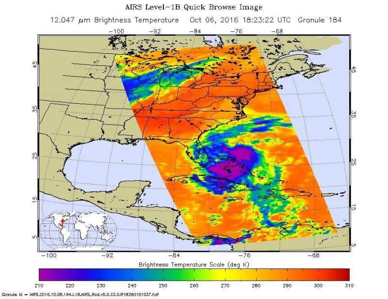
NASA's Atmospheric Infrared Sounder (AIRS) instrument on NASA's Aqua satellite captured this infrared view of Hurricane Matthew over the Bahamas at 11:27 a.m. PDT (2:27 p.m. EDT) on Oct. 6, 2016. The colors denote cloud top temperatures, with the most intense thunderstorms shown in purple and blue. Credit: NASA/JPL-Caltech
Hurricane Matthew, currently an extremely dangerous Category 4 storm on the Saffir-Simpson Hurricane Wind Scale, continues to bear down on the southeastern United States. At 11:27 a.m. PDT (2:27 p.m. EDT and 18:23 UT) today, NASA's Atmospheric Infrared Sounder (AIRS) instrument aboard NASA's Aqua satellite observed the storm as its eye was passing over the Bahamas. The AIRS false-color infrared image shows that the northeast and southwest quadrants of the storm had the coldest cloud tops, denoting the regions of the storm where the strongest precipitation was occurring at the time.
Data from the Advanced Microwave Sounding Unit (AMSU), another of AIRS' suite of instruments, indicate that the northeast quadrant, which appears smaller in the infrared image, likely had the most intense rain bands at the time. The AIRS infrared image shows that at the time of the image the storm had full circulation, with a small eye surrounded by a thick eye wall.
More information: For more information on AIRS, visit: airs.jpl.nasa.gov/
Provided by Jet Propulsion Laboratory


