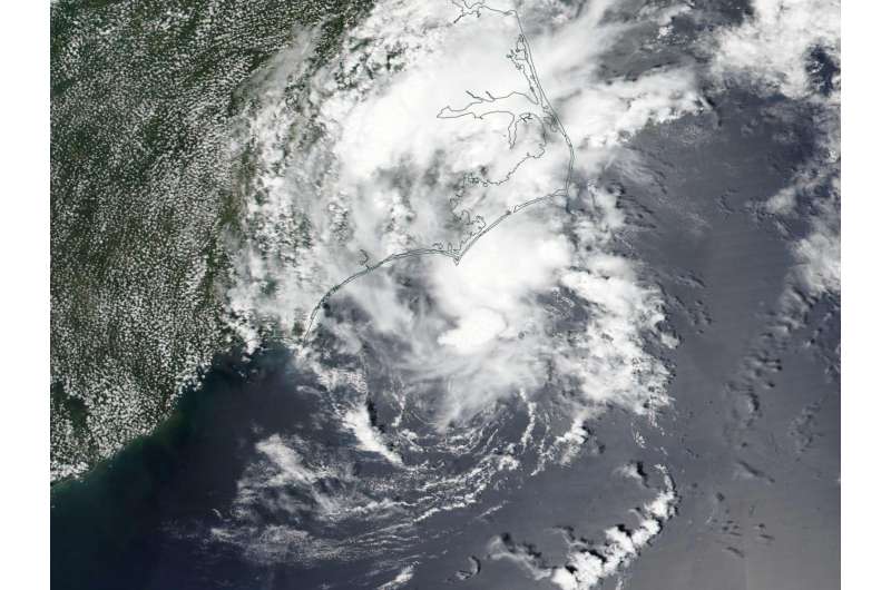
NASA sees a redeveloped Tropical Depression Bonnie over North Carolina

On the morning of June 2, the National Hurricane Center reported that post-tropical cyclone Bonnie has redeveloped into a tropical depression and was moving over the North Carolina Outer Banks. NASA-NOAA's Suomi NPP Satellite and NOAA's GOES-East satellite captured imagery and an animation that showed the movement of the storm.
Bonnie continues to pose a threat of heavy rain that is expected to continue today, June 2, in eastern North Carolina. The National Weather Service issued a flood watch and flood advisory for a small portion of the North Carolina Outer Banks.
A visible image of Bonnie was taken from the Visible Infrared Imaging Radiometer Suite (VIIRS) instrument aboard NASA-NOAA-DOD's Suomi NPP satellite on June 1, 2016. The image showed Bonnie when it was a post-tropical cyclone, moving over southeastern North Carolina. The strongest thunderstorms were northwest of the center of circulation over land and southeast of the center, over the Atlantic Ocean.Bonnie strengthened back to a depression early on June 2.
An animation NOAA's GOES-East satellite imagery from May 31 to June 2 was created at NASA's GOES Project at NASA's Goddard Space Flight Center in Greenbelt Maryland. The animation shows the slow northerly movement of Bonnie from South Carolina to North Carolina as it strengthened from a post-tropical cyclone back into a depression. NOAA manages the GOES-East satellite and the NASA GOES Project uses the satellite data to create images and animations.
The National Hurricane Center (NHC) said that at 11 a.m. EDT (1500 UTC) the center of Tropical Depression Bonnie was located near latitude 35.1 degrees north and longitude 75.1 degrees west. That puts the center of the redeveloped depression about 25 miles (40 km) east-southeast of Cape Hatteras, North Carolina. NHC said that Bonnie is moving toward the northeast near 7 mph (11 kph). A turn toward the east-northeast and an increase in forward speed are expected later today. On the forecast track, the center of Bonnie should/pre> move away from the coast of North Carolina this afternoon and tonight. Maximum sustained winds are near 30 mph (45 km/h) with higher gusts. Some slight strengthening is possible during the next 24 hours. After that time, Bonnie is expected to again become a post-tropical low.
For updates from the NHC, visit: http://www.nhc.noaa.gov
Provided by NASA's Goddard Space Flight Center


