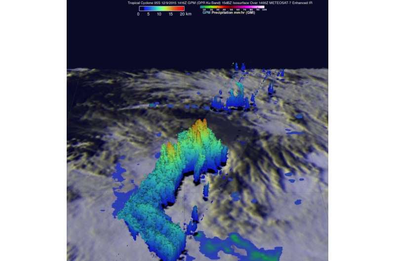
On Dec. 9 GPM measured thunderstorm tops reaching heights on Tropical Cyclone 05S (Bohale) above 16.6 km (10.3 miles) near the center of the developing tropical cyclone that were dropping rain at a rate of over 77 mm (~ 3 inches) per hour. Credit: NASA/JAXA/SSAI/Hal Pierce
NASA analyzed the rainfall rates occurring in Tropical Cyclone 05S, now renamed Tropical Cyclone Bohale.
On Dec. 10, Tropical cyclone 05S formed in the South Indian Ocean well to the northeast of the islands of Reunion and Mauritius and was re-named Bohale on Dec. 11. The Global Precipitation Measurement or GPM core observatory satellite had a perfect view of 05S when the satellite flew over on December 9, 2015 at 1416 UTC (9:16 a.m. EST). At that time the forming tropical cyclone had sustained winds estimated at 35 knots (40 mph). GPM found that 05S was dropping rain at a rate of over 77 mm (~ 3 inches) per hour in strong convective storms near the tropical cyclone's center of circulation. GPM also saw intense rainfall in a strong feeder band that was converging into the storm's southwestern side.
At NASA's Goddard Space Flight Center in Greenbelt, Maryland, a 3-D image was created using data derived from GPM's Radar (DPR Ku Band). The 3-D image showed the structure of precipitation within tropical cyclone 05S. GPM measured thunderstorm tops reaching heights above 16.6 km (10.3 miles) near the center of the developing tropical cyclone.
The Joint Typhoon Warning Center (JTWC) noted on Dec. 11 at 0900 UTC (4 a.m. EST) that Tropical cyclone Bohale's maximum sustained winds were near 40 knots (46 mph/74 kph). JTWC expects Bohale to strengthen slightly over the next day and a half before weakening again. It was centered near 16.5 degrees south latitude and 69.3 east longitude, about 594 nautical miles south-southwest of Diego Garcia. Bohale was moving to the south-southwest at 6 knots (6.9 mph/11.1 kph).
On Dec. 9 GPM measured thunderstorm tops reaching heights on Tropical Cyclone 05S (Bohale) above 16.6 km (10.3 miles) near the center of the developing tropical cyclone that were dropping rain at a rate of over 77 mm (~ 3 inches) per hour. Credit: NASA/JAXA/SSAI/Hal Pierce
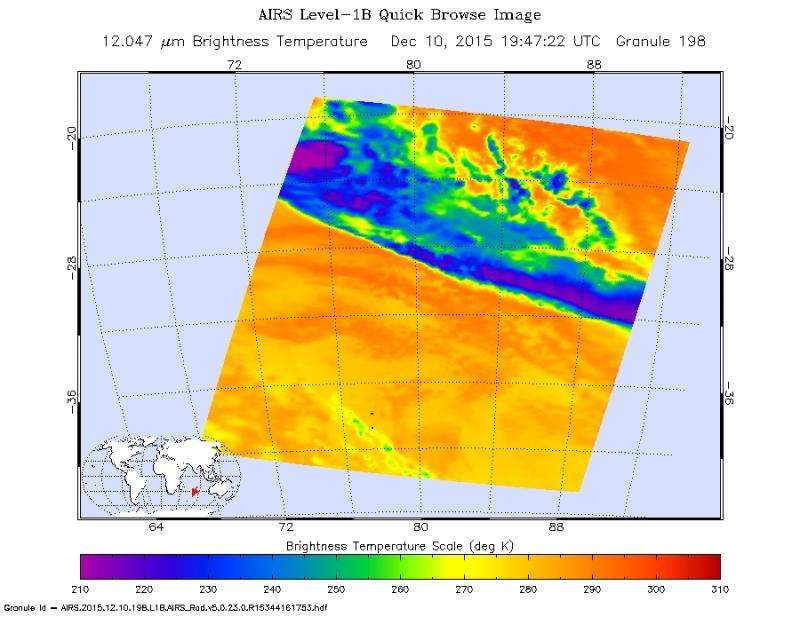
The AIRS instrument or Atmospheric Infrared Sounder that flies aboard NASA's Aqua satellite captured infrared data on Bohale on Dec. 10 at 1947 UTC (2:47 p.m. EST). Powerful thunderstorms with cold cloud top temperatures near minus 63 Fahrenheit (minus 53 Celsius) surrounded the center of circulation, and some of those powerful thunderstorms extended in a south-southeasterly direction. JWTC noted that "Animated infrared satellite Imagery shows a tightly wrapped low level circulation center with deep convection flaring as poleward outflow (south) and a brief period of reorganization has allowed the system to maintain intensity."
NASA's Aqua satellite captured this infrared image of Bohale on Dec. 10 at 2:47 p.m. EST that showed powerful thunderstorms with cold cloud top temperatures (purple) near minus 63 Fahrenheit (minus 53 Celsius) surrounded the center. Credit: NASA JPL/Ed Olsen
Bohale is expected to run into adverse conditions that will prompt a weakening trend as it passes far to the east of Rodrigues Island. Sea surface temperatures in the vicinity of Bohale are near 27 Celsius, which is just above the threshold to maintain the strength of a tropical cyclone. Sea surface temperatures that lie ahead of Bohale's path become cooler over the next two days and will not support a tropical cyclone. The Joint Typhoon Warning Center expects Bohale to weaken to a depression by Dec. 14.
Provided by NASA's Goddard Space Flight Center


