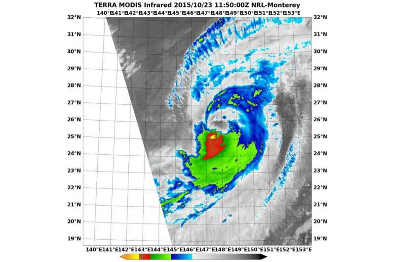
On Oct. 23 at 1150 UTC the MODIS instrument aboard NASA's Terra satellite showed Typhoon Champi's clouds and showers (red, yellow) stretching from southwest to northeast. Credit: NRL/NASA
Typhoon Champi appeared to be the victim of vertical wind shear in infrared imagery from NASA's Terra satellite. Champi has become elongated while moving through the western North Pacific Ocean and is expected to become extra-tropical by October 24.
On October 23 at 1150 UTC (7:50 a.m. EDT) the Moderate Resolution Imaging Spectroradiometer or MODIS instrument aboard NASA's Terra satellite showed evidence of wind shear in Typhoon Champi as its clouds stretched from southwest to northeast. The Joint Typhoon Warning Center said that satellite imagery showed "a ragged eye feature with continued deterioration of the convective structure as it becomes further elongated to the northeast."
It was located near 25.7 degrees north latitude and 148.1 east longitude, about 643 nautical miles north of Saipan. Champi had maximum sustained winds near 80 knots (92.0 mph/148.2 kph). It was moving to the east at 15 knots (17.2 mph/27.7 kph).
The Moderate Resolution Imaging Spectroradiometer or MODIS instrument aboard NASA's Aqua satellite captured a visible image of extra-tropical cyclone 26W on October 23 at 0225 UTC (Oct. 22 at 10:25 p.m. EDT). The MODIS image showed evidence of wind shear as the bulk of clouds were pushed from the southwest to the northeast of the center.
The Joint Typhoon Warning Center noted that upper level (atmospheric) analysis indicated that Champi was in a poor environment with vertical wind shear in excess of 30 knots (34. 5 mph/55.5 kph).
The Joint Typhoon Warning Center expects Champi to continue moving east and weaken before transitioning to an extra-tropical system on Saturday, October 24.
Provided by NASA's Goddard Space Flight Center


