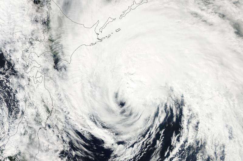
On Sept. 11 at 03:35 UTC the MODIS instrument aboard NASA's Aqua satellite captured this visible image of Tropical Storm Kilo brushing northern Japan. Credit: NASA Goddard MODIS Rapid Response Team
NASA's Aqua satellite spotted Tropical Storm Kilo brushing the eastern side of Hokkaido, Japan early on September 11 as it was becoming extra-tropical.
At 03:35 UTC (11:35 p.m. EDT on Sept. 10) the Moderate Resolution Imaging Spectroradiometer or MODIS instrument aboard NASA's Aqua satellite captured a visible image of Tropical Storm Kilo brushing northern Japan. The center of Kilo was east of northern Honshu (the largest island in Japan) and clouds and storms in Kilo's northwestern quadrant were over the island of Hokkaido, Japan's northernmost island. Kilo is a large storm with tropical-storm-force winds of 34 knots (39.1 mph/62.9 kph) or higher occurring up to 225 nautical miles (259.1 miles/417 km) from the center.
The Joint Typhoon Warning Center issued their final warning on the system at 0300 UTC on September 11 (11 p.m. EDT, Sept. 10), marking the end of the system after three weeks as a tropical cyclone. Kilo's center was near 38.5 North latitude and 147.4 East longitude, about 309 nautical miles east-southeast of Misawa, Japan.
Kilo's maximum sustained winds were near 45 knots (51.7 mph/83.3 kph) and it was moving to the north-northwest at 17 knots (19.5 mph/31.4 kph).
The Joint Typhoon Warning Center noted that Kilo is now tracking over sea surface temperatures of 77 degrees Fahrenheit (25 degrees Celsius). Tropical cyclones need sea surface temperatures of at least 26.6C/80F to maintain intensity and tropical characteristics. The JTWC noted that as Kilo continues moving north, sea surface temperatures will drop rapidly, helping the system transition to an extra-tropical storm.
Kilo is becoming an extra-tropical storm as it approaches the southern Kuril Islands. The islands are part of Russia's Sakhalin Oblast region and are an archipelago that covers about 810 miles (1,300 km) from northern Japan to Kamchatka, Russia.
When a tropical cyclone becomes extra-tropical it has lost its "tropical" characteristics. According to the National Oceanic and Atmospheric Administration, the term "extra-tropical" implies both poleward displacement (it moves closer to the north or south pole depending on what hemisphere it is located in) of the cyclone and the conversion of the cyclone's primary energy source from the release of latent heat of condensation to baroclinic (the temperature contrast between warm and cold air masses) processes. It is important to note that cyclones can become extra-tropical and still retain winds of hurricane or tropical storm force.
Kilo is expected to pass through the Kuril Islands and move into the Sea of Okhotsk by September 12 where it is forecast to dissipate.
Provided by NASA's Goddard Space Flight Center


