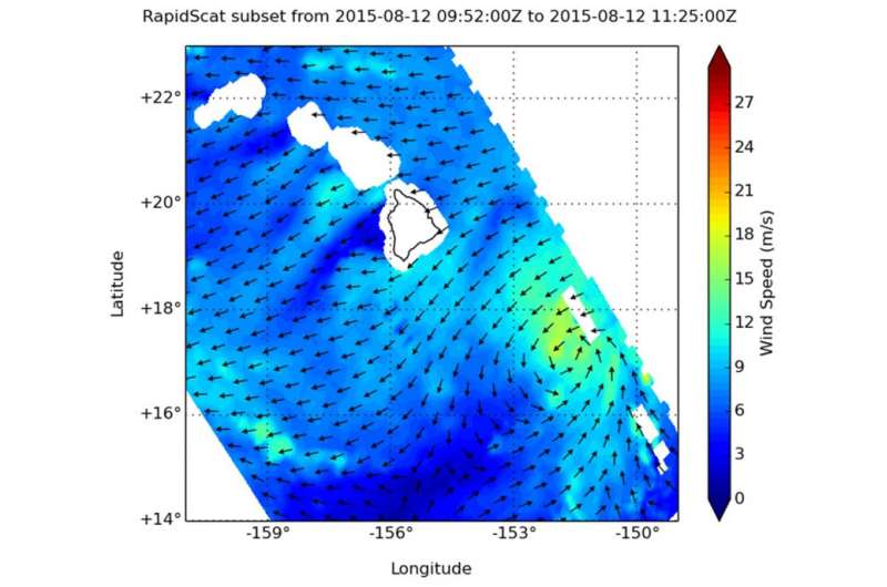
On August 12 at 7 a.m. EDT RapidScat observed tropical-storm-force winds (yellow/orange) on Hilda's northwestern side. Credit: NASA JPL, Doug Tyler
As Tropical Storm Hilda creeps closer to the Big Island of Hawaii, NASA's RapidScat instrument that flies aboard the International Space Station observed its diminishing winds.
RapidScat gathers data on surface winds occurring over the ocean. On Wednesday, August 12 at 1100 UTC (7 a.m. EDT), RapidScat observed tropical-storm-force winds on Hilda's northwestern side. Those winds were as strong as 20 meters per second (45 mph/72 kph) while weaker sustained winds were occurring around the rest of the storm.
By 0900 UTC (5 a.m. EDT) on August 13, maximum sustained winds were holding near 45 mph (75 kph), but NOAA's Central Pacific Hurricane Center (CPHC) forecast calls for Hilda to gradually weaken through late Friday, August 14.
Hilda's center was located near latitude 17.2 north...longitude 152.5 west. That puts the center of Hilda about 240 miles (390 km) southeast of Hilo, Hawaii and about 450 miles (725 km) southeast of Honolulu, Hawaii. Hilda was moving toward the west near 5 mph (7 kph) and is expected to move to the west-southwest later in the day through August 14. The estimated minimum central pressure is 1003 millibars.
The center of Hilda is now expected to stay south of the Big Island and move to the west-southwest. However, RapidScat showed that the strongest winds were occurring north of the center.
NOAA's CPHC said that east and southeast facing shores of portions of the Hawaiian Islands will experience swells and large surf. Hilda may produce heavy rainfall along and north of its path. These rains could result in life threatening flash floods and mud slides across portions of the Hawaiian Islands tonight (August 13) into Saturday, August 15.
For updated forecasts, watches and warnings, visit CPHC's website: http://www.prh.noaa.gov/
Provided by NASA's Goddard Space Flight Center


