NASA sees heavy rain in Hurricane Hilda, south Of Hawaii

Hurricane Hilda has been on a weakening trend and by August 12 it weakened to a Tropical Storm. When it was still a hurricane though, NASA satellite data showed that the northern side of the storm contained towering thunderstorms that were dropping heavy rainfall.
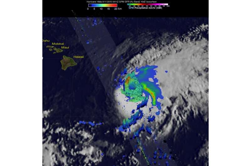
Hilda had winds of about 80 knots (92 mph) when the GPM core observatory satellite passed above on August 11, 2015 at 0411 UTC (August 10, 2015 at 6:11 p.m. HST). Rainfall data from GPM's Microwave Imager (GMI) and Dual-Frequency Precipitation Radar (DPR) instruments were combined with an infrared image of clouds from NOAA's GOES West satellite taken at 0400 UTC on August 11. The combined image showed the cloud extent and rainfall within the storm. GPM's DPR revealed that storms north of hurricane Hilda's eye were dropping rain at a rate of over 149.4 mm (5.9 inches) per hour.
At NASA's Goddard Space Flight Center in Greenbelt, Maryland that data from GPM's radar data (DPR Ku band) were used to make a 3-D image that showed the heights of the thunderstorm tops within Hilda. The highest cloud tops were found near altitudes of over 16.5 km (10.2 miles) in powerful storms in the northwestern side of Hilda's eye wall.
As Hilda neared the big Island of Hawaii, NOAA's Central Pacific Hurricane Center posted a tropical storm watch for Hawaii County.
At 11 a.m. EDT/5 a.m. HST/1500 UTC on Wednesday, August 12, Hilda's maximum sustained winds had dropped to 45 mph (75 kph) and further weakening was forecast. The center of Tropical Storm Hilda was located near latitude 17.5 north and longitude 152.0 west. Hilda was moving toward the northwest near 5 mph (7 kph) and is expected to turn west through August 13.
Hilda is forecast to be a tropical depression tonight (August 12) or Thursday (August 13) and a remnant low by Thursday night.
Provided by NASA's Goddard Space Flight Center


