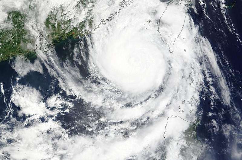
NASA's Aqua satellite saw Tropical Storm Linfa approaching the southeastern China coast on July 8 at 03:00 UTC (11 p.m. EDT, July 7). Credit: NASA Goddard MODIS Rapid Response Team
NASA's Aqua satellite provided a bird's eye view of Tropical Storm Linfa as it was approaching the southeastern China coast on July 8. NASA's RapidScat instrument found that the typhoon's strongest winds were on its eastern side toward Taiwan and away from China. Both countries have posted warnings on July 8.
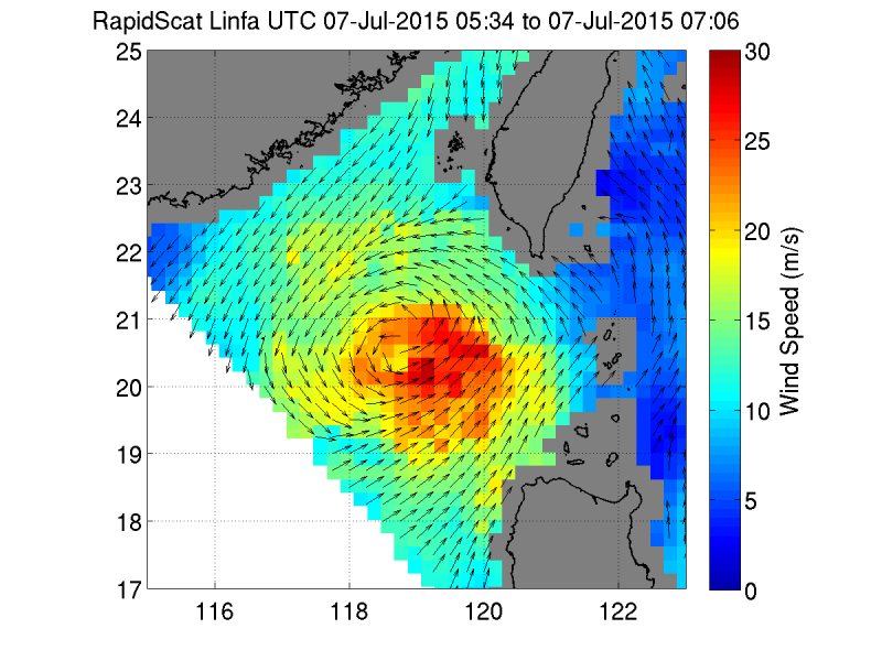
On July 7, the RapidScat instrument that flies aboard the International Space Station, observed Linfa's strongest winds on the eastern side of the storm, reaching speeds of 30 meters per second (108 kph/67 mph). Linfa is in the southern part of the Taiwan Strait and moving toward landfall in southeastern China.
NASA's Aqua satellite saw Tropical Storm Linfa approaching the southeastern China coast on July 8 at 03:00 UTC (11 p.m. EDT, July 7). The image, taken by the MODIS instrument aboard Aqua, hinted at the formation of an eye. Animated enhanced infrared imagery revealed that eye. The MODIS image also showed good banding of thunderstorms wrapping around the center of circulation.
On July 8 at 1500 UTC (11 a.m. EDT), Tropical storm Linfa had maximum sustained winds near 60 knots (69 mph/111 kph). It was centered 22.3 North latitude and 118.1 East longitude, about 233 nautical miles (268 miles/431.5 km) east of Hong Kong, China. It was moving to the northwest at 5 knots (5.7 mph/9.2 kph) and is generating rough seas in the southern Taiwan Strait with waves to 22 feet (6.7 meters).
On July 7, ISS- RapidScat observed Linfa's strongest winds on the eastern side of the storm, reaching speeds of 30 meters per second (in red) (108 kph/67 mph). Credit: NASA JPL, Doug Tyler
Because Linfa is in the southern part of the Taiwan Strait, it is affecting Taiwan to the east and China to the west. Both countries have warnings in effect.
Several warnings are in effect for Taiwan. The Taiwan Central Weather Bureau (TCWB) issued "extremely heavy rain" warnings for Yunlin County, Tainan and Kaohsiung Cities, Hualien, Hantou and Chiayi Counties. "Heavy rain" warnings were issued for Penghu, Changhua, Yunlin, Nantou and Chiayi counties and Chaiyi City. A "torrential rain" warning is in effect for Ludao and Lanyu, and Taitun and Pingtung Counties. For more information and updated warnings from TCWB, visit: http://www.cwb.gov.tw.
China's National Meteorological Centre has (CNMC) issued a Yellow typhoon warning and a Blue rainfall warning for the area in which Linfa is expected to impact. In Hong Kong, standby signal #1 is in effect and signal #3 could be issued later on July 8.
At 5 p.m. EDT on July 7/5 a.m. on July 8 Asia/Shanghai local time, Tropical Storm Linfa was located in northeastern South China Sea, about 300 kilometers southeast of the border of Guangdong and Fujian. The CNMC expects Linfa to make land fall along the coast of Shanwei of Guangdong Province and Zhangpu of Fujian Province on July 9. The National Meteorological Center continues to issue a yellow warning of typhoon.
The Blue warning for heavy rain covers July 8 and 9 and encompasses the area that includes southern Fujian, eastern Guangdong, southern Taiwan, southwestern Anhui, western Inner Mongolia, central Gansu and the northern Sichuan Basin. For updated warnings and watches from China's National Meteorological Centre, visit: http://www.cma.gov.cn/en/WeatherWarnings/.
The Joint Typhoon Warning Center's latest forecast (on July 8) calls for Linfa to make landfall and then skirt along the coast of China in a southwesterly direction, passing through Hong Kong and curving over the eastern half of Hainan Island by July 11.
Provided by NASA's Goddard Space Flight Center


