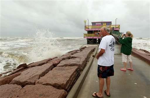
Darrell Mayo shoots video of the rough surf from Tropical Storm Bill on Tuesday, June 16, 2015, at Galveston's 61st Street Fishing Pier as Tropical Storm Bill makes landfall near Matagorda Bay on the Texas Gulf coast. (Jennifer Reynolds/The Galveston County Daily News via AP)
Tropical Storm Bill moved slowly over inland Texas on Tuesday, bringing another round of heavy rains to a state weary from recent deadly floods, evacuations and washed-out roads.
The storm came ashore shortly before noon along Matagorda Island with maximum sustained winds of 60 mph, according to the National Hurricane Center in Miami.
Personnel from the Federal Emergency Management Agency who were sent to Texas and Oklahoma after severe flooding over Memorial Day weekend will remain in the region to help prepare for Tropical Storm Bill and help clean up in its aftermath, White House spokesman Josh Earnest said Tuesday.
"I'm not afraid; we've had so many storms," said Maria Cedillo, who stopped by fishing boats docked in Corpus Christi on Tuesday to buy crabs. "When there's a big one coming we move out. But this isn't one of them."
According to projections by the National Weather Service, average rainfall through noon Wednesday for portions of Texas will be 3 to 6 inches, but some isolated areas could see up to 12 inches. Arkansas and Oklahoma could get up to 9 inches of rain in the coming days, and Missouri could get more than 7. After last month's historic rains and floods, the forecast was expected to complicate ongoing flood-containment efforts.
Major flooding could occur along the Trinity River as it extends through East Texas, according to the weather service, with one portion northeast of Houston nearly 4 feet above flood stage Tuesday. The Guadalupe River north of Corpus Christi also is swollen as it ran more than 5 feet above flood stage.
"We're more vulnerable to flooding right now than usual because we just got through the wettest month on record," Texas state climatologist John Nielsen-Gammon said.
Galveston County officials already have directed voluntary evacuation of the low-lying Bolivar Peninsula, where Hurricane Ike wiped out most structures in 2008. School districts from Galveston to the Houston suburbs canceled Tuesday's classes and the Coast Guard closed waterways and prohibited the use of smaller vessels. The National Weather Service has issued flash flood warnings for many coastal areas and tornado warnings for other areas.
The ground remains waterlogged in many parts of Texas so it's unable to absorb much more rain, he said, and that increases the likelihood of flooding.
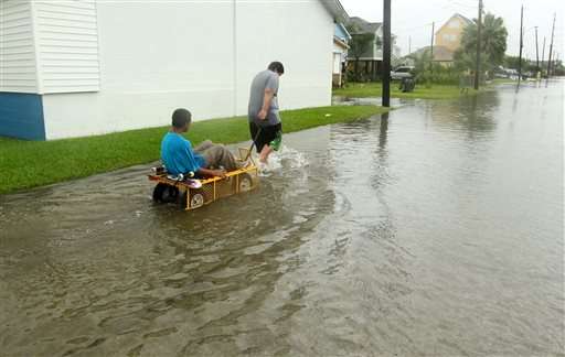
Manuel Martinez pulls Jesse McGehee through high water on Saladia Street in Galveston, Texas on Tuesday June 16, 2015. High tides cause by Tropical Storm Bill flooded several low-lying streets. (Jennifer Reynolds/The Galveston County Daily News via AP)
Nielsen-Gammon said it's not unusual for tropical storms to swarm Texas in June, but he notes it's the early-season storms that are responsible for about a third of "extreme rainfall events," meaning 20 inches or more of rain.
An average statewide rainfall of nearly 9 inches was recorded in May, he said, which is more than 2 inches above the previous record.
Memorial Day weekend storms brought widespread flooding to Oklahoma and Texas, killing more than 30 people. At one point last month, 11 inches of rain fell in some parts of the Houston area, resulting in flooding that damaged thousands of homes and other structures and forced motorists to abandon at least 2,500 vehicles across Houston.
Rafael Lemaitre, spokesman for the Federal Emergency Management Agency, said FEMA has paid nearly $38 million this year in Texas flood insurance claims, with the vast majority associated with last month's deluge.
More than 10 inches of rain fell over a 30-day period across nearly the entire central and eastern portions of Texas—from the Panhandle south to the Mexico border. Isolated areas received 15 to more than 20 inches.
Those wet conditions could help strengthen the storm, according to Marshall Shepherd, director of atmospheric sciences at the University of Georgia.
While tropical storms usually gather power from the warm waters of the ocean and then weaken once they move over land, NASA-funded research has shown some storms can actually strengthen over land by drawing from the evaporation of abundant soil moisture, Shepherd said. The phenomenon is known as the "brown ocean" effect.
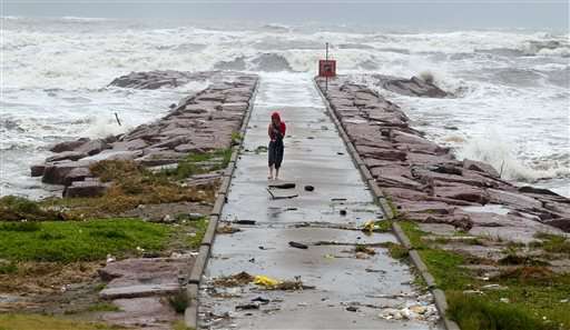
A woman walks back from watching the waves roll over the end of the 29th Street Galveston rock groin Tuesday, June 16, 2015, in Galveston, Texas as Tropical Storm Bill makes landfall near Matagorda Bay on the Texas Gulf coast. (Rachel Denny Clow/Corpus Christi Caller-Times via AP)
"All the things a hurricane likes over the ocean is what we have over land right now," said Shepherd, one of the principals who conducted the research.
On Monday, portions of the Red River were near or above flood stage as it runs between Oklahoma and Texas and then extends into Louisiana. Meanwhile, the Trinity River was above flood stage in many areas of East Texas.
Lake levels across Oklahoma remain high from May rainfall, which has forecasters watching rivers in Arkansas ahead of the tropical system.
"We have had time to recover but not a whole lot," said NWS hydrologist Tabitha Clarke in North Little Rock, Arkansas. "(The tropical system) is going over areas that are already sensitive. ... It's kind of a perfect storm. There are a lot of things lining up."
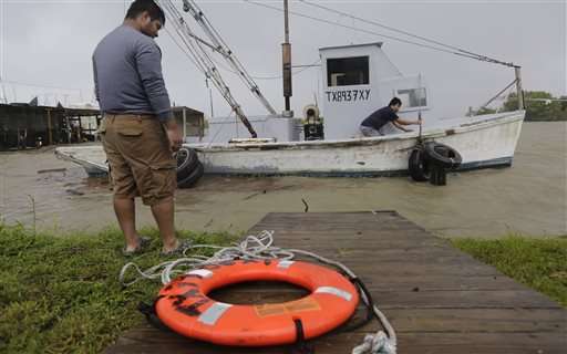
Oyster fishermen try to secure their boat as Tropical Storm Bill makes landfall, Tuesday, June 16, 2015, in Port Lavaca, Texas. (AP Photo/Eric Gay)
Shepherd said it won't be immediately known if the brown ocean effect holds true for this storm but an indicator will be whether it forms an eye while well inland. He cautioned that often it's not the larger category storms that produce the most rainfall, but instead smaller tropical storms.
© 2015 The Associated Press. All rights reserved.


