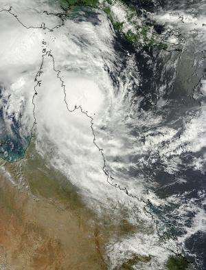
On March 12 at 00:30 UTC NASA's Terra satellite took this image of Tropical Cyclone Nathan in the Coral Sea, just off the coast of Queensland, Australia's Cape York Peninsula. Credit: NASA Goddard MODIS Rapid Response Team
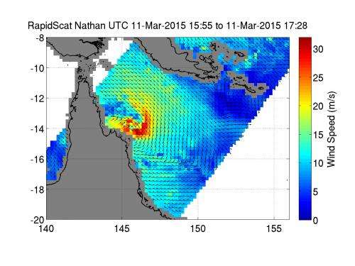
The RapidScat instrument aboard the International Space Station analyzed Tropical Cyclone Nathan's winds while NASA's Terra satellite provided an overall look at the extent of the storm along Queensland, Australia's Cape York Peninsula.
The International Space Station's RapidScat instrument captured data on Nathan's winds on March 11 from 15:55 to 17:28 UTC (11:55 a.m. to 1:28 p.m. EDT). RapidScat revealed sustained winds over 30 meters per second (108 kph/67 mph) occurring southeast and east of Tropical Cyclone Nathan's center making it a strong tropical storm. The next day, those sustained winds had weakened only slightly.
On March 12 at 00:30 UTC (March 11 at 8:30 p.m. EDT), the Moderate Resolution Imaging Spectroradiometer or MODIS instrument aboard NASA's Terra satellite took a visible image of Tropical Cyclone Nathan in the Coral Sea, when it was hugging the eastern coast of Queensland's Cape York Peninsula from the Lockhart River south to Cape Flattery.
The Australian Bureau of Meteorology (ABM) noted on March 12 at 10 p.m. local time (8 a.m. EDT/1200 UTC) sustained winds near the center of 100 kilometers (62 mph) per hour. Nathan's center was near 13.8 degrees south and 145.0 degrees East, about 65 kilometers (40 miles) northeast of Cape Melville and 190 kilometers (119 miles) north of Cooktown. Nathan is moving to the northwest at 4 kph (2.4 mph) in its cyclonic loop and expected to slowly turn to the north. At that time, Cyclone Nathan was moving off the northeast Queensland coast between Coen and Cape Flattery but is expected to start turning away from the coast on March 13.
On March 11, RapidScat revealed sustained winds (in red) over 30 meters per second (108 kph/67 mph) occurring southeast and east of Tropical Cyclone Nathan's center. Credit: NASA JPL, Doug Tyler
ABM's forecast noted "Areas of heavy rain will continue about parts of the Peninsula and North Tropical Coast and Tablelands districts overnight before gradually easing during Friday as the cyclone moves away from the coast." A Flood Watch was in effect for the North Tropical Coast catchments north of Innisfail. ABM cautioned that abnormally high tides could develop about coastal and island areas between Coen and Cape Flattery on March 13.
For updated forecasts from ABM, visit: http://www.bom.gov.au/cyclone.
Provided by NASA's Goddard Space Flight Center


