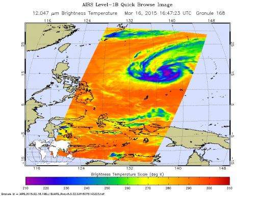
This false-colored image shows warming infrared temperature data of Tropical Cyclone Bavi's clouds on March 16 at 16:47 UTC, as seen by the AIRS instrument aboard NASA's Aqua satellite. Credit: NASA JPL
Tropical Cyclone Bavi's convection and developing thunderstorms have been waning because of wind shear, and NASA's Aqua satellite provided an infrared look at the weakening storm.
The Atmospheric Infrared Sounder or AIRS instrument that flies aboard NASA's Aqua satellite revealed warming infrared temperature data of Tropical Cyclone Bavi's clouds on March 16 at 16:47 UTC (10:47 a.m. EDT). At 0900 UTC (5 a.m. EDT) on March 17, 2015 the Joint Typhoon Warning Center (JTWC) noted that "Recent animated enhanced infrared satellite imagery showed the system is stripped of any significant deep convection." That's as a result of moderate to strong (20 to 30 knot/23 to 34.5 mph/37 to 55.5 kph) southwesterly vertical wind shear. The imagery showed a ragged low-level circulation center and cloud top temperatures had warmed over the previous 24 hours. Warming cloud tops indicate that the cloud tops are dropping and the storms are weakening.
Bavi has weakened to a depression with maximum sustained winds near 30 knots (35 mph/55 kph). Bavi was centered near 15.6 north latitude and134.5 east longitude, about 784 nautical miles (902 miles/1,453 km) east of Manila, Philippines. Bavi was moving to the west-northwest at 8 knots (9.2 mph/14.8 kph).
Bavi is moving to the west, tracking along the southern edge of a sub-tropical ridge (elongated area) of high pressure to the north. The JTWC expects Bavi to dissipate in the next day or two.
Provided by NASA's Goddard Space Flight Center


