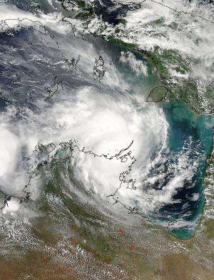
Tropical Cyclone Lam was making landfall over the Northeast Territory of Australia when NASA's Aqua satellite saw it on Feb. 19, 2015 at 4:40 UTC. Credit: NASA Goddard MODIS Rapid Response Team
As Tropical Cyclone Lam made landfall in Australia's Northern Territory on Feb. 19 (EST), NASA satellites and instruments gathered data on the storm's structure and behavior. Two instruments aboard NASA's Aqua satellite, NASA-JAXA's GPM core satellite, the RapidScat instrument aboard the International Space Station provided information to forecasters before and after Lam came ashore.
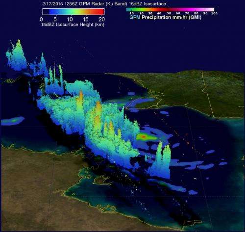
On Feb. 17 when Lam was strengthening in the Arafura Sea, NASA and the Japan Aerospace Exploration Agency's Global Precipitation Measurement or GPM core observatory satellite passed over Tropical Cyclone Lam at 1256 UTC and captured data on the rainfall rates within the storm. At that time, sustained winds were estimated to be increasing above 55 knots (63 mph). GPM's Microwave Imager (GMI) measured rain falling at a rate of almost 55 mm (2.2 inches) per hour in powerful storms to the northwest of Lam's center. A 3-D view of cyclone Lam's vertical structure was made possible by using GPM's radar (Ku band) data that showed some thunderstorm tops above 7.8 miles (12.6 km).
Another instrument took a look at the winds of the storm from its perch in space. The International Space Station's RapidScat instrument captured a look at Tropical Cyclone Lam's winds as it was moving toward landfall. From Feb. 18 at 1:40 UTC to 3:13 UTC RapidScat saw sustained winds to 56 mph/90 kph/25 mps.
The Moderate Resolution Imaging Spectroradiometer instrument aboard NASA's Aqua satellite captured a stunning picture of the storm as the center was making landfall on Feb. 19 at 04:40 UTC. The center was an eye-like feature obscured by clouds as it exited the Arafura Sea and came ashore near Elcho and Howard Islands in the northeastern part of the Northern Territory.
The GPM core observatory found rainfall at 55 mm/2.2 inches per hour in Tropical Cyclone Lam on February 17, 2015 at 1256 UTC northwest of the center. Some cloud tops reached 7.8 miles high. Credit: NASA/JAXA
Another instrument aboard NASA's Aqua satellite provided infrared data on the thunderstorms that make up the tropical cyclone. A tropical cyclone is made up of hundreds of thunderstorms. The Atmospheric Infrared Sounder or AIRS instrument aboard Aqua gathers infrared data to provide temperature data. The higher the thunderstorm in the troposphere, the colder the cloud tops. AIRS saw cloud tops around the center of circulation as cold as -63F/-52C. NASA research has shown that thunderstorm cloud tops that cold have the potential to drop heavy rainfall, which mirrors and confirms the GPM core satellites observations even two days before.
On Feb. 19 (EST)/Feb. 20 1 a.m. local time, Brisbane, the Australian Bureau of Meteorology (ABM) noted "The very destructive core of Cyclone Lam is impacting the mainland coast between Milingimbi and Elcho Island." Warning zone: Goulburn Island to Port Roper, including Nhulunbuy, Groote Eylandt and adjacent inland areas to Bulman. For the updated ABM warnings and watches, visit: http://www.bom.gov.au/products/IDD65011.shtml
At 0900 UTC (4 a.m. EST) on Feb. 19, Tropical Cyclone Lam was centered near 11.7 south latitude and 135.7 east longitude, about 286 nautical miles (329.1 miles/529.7 km) east-northeast of Darwin, Australia and moving to the southwest at 4 knots(4.6 mph/7.4 kph). Maximum sustained winds 90 knots (103.6 mph/166.7 kph). By 10:30 a.m. EST (Feb. 20 at 1:30 a.m. local Darwin time) the ABM noted that Lam's sustained winds were near 99.9 knots/115 mph/185 mph.
There are many warnings and watches in effect. A Cyclone Warning is in effect from Goulburn Island to Cape Shield, including Nhulunbuy and Groote Eylandt. A Cyclone Watch: Numbulwar to Port Roper.
According to the latest report from the Australian Bureau of Meterology, on Feb. 19 at 15:30 UTC (10:30 a.m. EST/Feb. 20 at 1:30 a.m. local Darwin time) Lam's center was near 12.2 degrees south and 135.0 degrees east. That puts the center of Lam about 37 miles (60 kilometers) west-southwest of Galiwinku and 9 miles (15 kilometers) east southeast of Milingimbi. Lam is moving to the southwest at 4.9 mph (8 kph).
Tropical Cyclone Lam is forecast to continue moving southwest and weaken later in the day as it moves inland over Arnhem Land.
Provided by NASA's Goddard Space Flight Center


