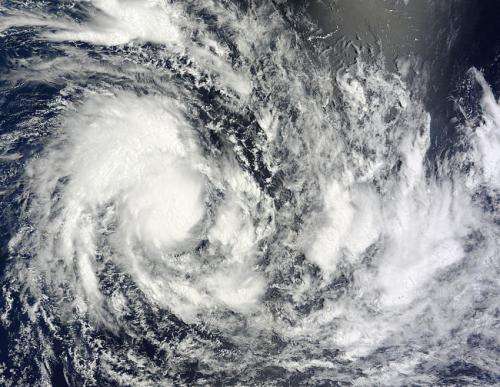
On Feb. 24 at 05:25 UTC, NASA's Terra satellite captured this visible image of newborn Tropical Cyclone Fourteen in the Southern Indian Ocean. Credit: NASA Goddard MODIS Rapid Response Team
A tropical low pressure area designated as System 90S formed in the Southern Indian Ocean on February 21, 2015 and has been slowly organizing and consolidating. Three days later System 90S became Tropical Storm 14S as NASA's Terra satellite passed overhead.
On Feb. 24 at 05:25 UTC (12:25 a.m. EST), NASA's Terra satellite flew over newborn Tropical Cyclone Fourteen S. The MODIS or Moderate Resolution Imaging Spectroradiometer instrument took a visible picture of the storm that showed strong thunderstorms circling the center. The image also showed fragmented bands of thunderstorms from the east to the south, wrapping into the center of circulation from the southwestern quadrant of the storm. Another large more organized band of thunderstorms wrapped into the center from the western side of the storm.
At 0900 UTC (4 a.m. EST), Tropical Storm 14S had maximum sustained winds near 35 knots (40 mph/62 kph). It was centered near 16.2 south latitude and 72.2 east longitude, about 546 nautical miles (628.3 miles/1,011 km) south of Diego Garcia. It was moving to the west at 5 knots (5.7 mph/ 9.2 kph) and it no threat to land areas.
Forecasters at the Joint Typhoon Warning Center expect 14S to gradually intensify over the next three days while moving west. The system is forecast to peak at 75 knots before turning to the southeast and becoming extra-tropical.
Provided by NASA's Goddard Space Flight Center


