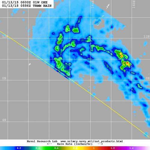
The TRMM satellite passed over Tropical Depression 1W on Jan. 13, 2015 at 12:56 a.m. EST and saw two large broken bands of thunderstorms north of the center where rain was falling at a rate of 1 inch to 1.2 inches (25 to 20 mm) per hour. Credit: NASA/JAXA/NRL
NASA/JAXA's TRMM Satellite passed over newborn Tropical Depression 1W after it came together in the Northwestern Pacific Ocean on January 13 and saw bands of moderate to heavy rainfall wrapping around the northern quadrant of the storm.
The Tropical Rainfall Measuring Mission or TRMM satellite is managed by both NASA and the Japan Aerospace Exploration Agency called JAXA. TRMM can measure the rate in which rain is falling from its orbit over the Earth's tropics. When it passed over Tropical Depression 1W (TD1W) on January 13 at 0556 UTC (12:56 a.m. EST) data showed two large broken bands of thunderstorms north of the center of circulation that contained moderate to heavy rainfall where rain was falling at a rate of 1 inch to 1.2 inches (25 to 20 mm) per hour. The bulk of rainfall was occurring over the west-northwestern quadrant.
On Jan. 13 at 1500 UTC (10 a.m. EST) TD1W had maximum sustained winds near 25 knots (28.7 mph/46.3 kph). It was located about 222 nautical miles (255.5 miles/411.1 km) east of Yap, near 8.9 north latitude and 141.8 east longitude. It was moving to the west-northwest at 8 knots (9.2 mph/14.8 kph).
The Joint Typhoon Warning Center expects TD1W to move in a west-northwesterly direction and intensify to tropical storm status on approach to the east central Philippines by January 17.
Provided by NASA's Goddard Space Flight Center


