NASA observes Super Typhoon Hagupit; Philippines under warnings

Forecasters at the Joint Typhoon Warning Center expect Super Typhoon Hagupit to reach peak intensity today, Dec. 4, and although expected to weaken, will remain a Category 4 typhoon when it approaches the east central Philippines. NASA's Terra satellite and NASA/JAXA's GPM and TRMM satellites have been providing forecasters with valuable data on the storm. Computer models have varied on their track for the storm based on the strength of an upper-level system, so satellite data is extremely valuable in helping determine where Hagupit will move.
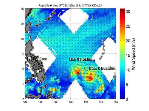
On Dec. 3, typhoon Hagupit was moving from near Palau toward the Philippines when it was examined by two satellites managed by NASA and the Japan Aerospace Exploration Agency known as JAXA. The Tropical Rainfall Measuring Mission or TRMM satellite and the Global Precipitation Measurement or GPM core satellite passed over Hagupit and gathered rainfall and cloud height data.
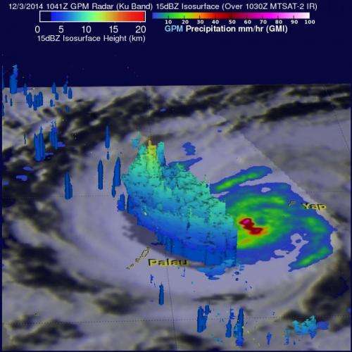
The TRMM satellite traveled directly over Typhoon Hagupit's eye on December 3, 2014 at 0342 UTC (Dec. 2 at 10:42 p.m. EST). The GPM (core satellite) had a good view of Hagupit later at 1041 UTC (5:41 a.m. EST) Rainfall data captured at that time with GPM's Microwave Imager (GMI) instrument shows that rain was falling at a rate of over 138 mm (~5.4 inches) per hour in the western side of Hagupit's eye.
At NASA's Goddard Space Flight Center in Greenbelt, Maryland the data from the Ku band on GPM's dual frequency radar instrument (DPR) was used to create a 3-D image. The Ku band radar swath showed powerful thunderstorms reaching heights of over 15.8 km (9.8 miles) in feeder bands west of Typhoon Hagupit's eye.

On Dec. 4 at 02:10 UTC, the MODIS (Moderate Resolution Imaging Spectroradiometer) instrument aboard NASA's Terra satellite took a visible image of Super Typhoon Hagupit approaching the Philippines. The MODIS image showed a clear eye surrounded by strong thunderstorms and bands of thunderstorms wrapping into the low-level center. The image also showed that the bulk of strongest thunderstorms were being pushed slightly west of the center as a result of easterly wind shear.
At 1500 UTC (10 a.m. EST) Typhoon Hagupit's maximum sustained winds were near 150 knots (172.6 mph/ 277.8 kph). Currently, typhoon-force winds of 64 knots (74 mph/118.5 kph) or higher occur out to 55 miles of the center. Tropical Storm-force winds of 34 knots (39 mph/63 kph) or higher occur within 85 to 140 miles of the center. The eye was centered near 11.1 north longitude and 130.9 east latitude, about 640 nautical miles (736 miles/1,185 km) east-southeast of Manila, Philippines. Hagupit was moving to the west-northwest at 12 knots 13.8 mph/22.2 kph).
Warnings in Effect
Philippines warnings in effect as of Dec. 4 include: Public storm warning signal #2 for the following provinces: Visayas: Northern and eastern Samar, Samar, Biliran, Leyte and southern Leyte
Mindanao: Dinagat Island and Siargao Island. And public storm warning signal #1 in effect for the following provinces: Visayas: Northern Cebu including Bantayan island, Camotes island and Bohol; Mindanao: Surigao del Norte & Sur, Camiguin Island and Agusan del Norte; Luzon: Catanduanes, Albay, Sorsogon, Ticao Island and Masbate.
As satellites gather more information, computer models will update atmospheric conditions that will steer the storm and forecasters will reassess the track as Hagupit nears the Philippines over the next couple of days.
Provided by NASA's Goddard Space Flight Center


