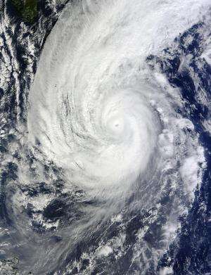
NASA's Terra satellite sees Typhoon Nuri in eyewall replacement

High clouds had moved over Super Typhoon Nuri's eye early on Nov. 4 when NASA's Terra satellite passed overhead as the storm was undergoing eyewall replacement.
Eyewall replacement occurs when the thunderstorms that circle the eye of a powerful typhoons or hurricanes are replaced by other thunderstorms. Basically, a new eye begins to develop around the old eye. Many intense hurricanes undergo at least one of these eyewall replacements during their existence.
On Nov. 4 at 01:55 UTC (8:55 p.m. EST) the Moderate Resolution Imaging Spectroradiometer or MODIS instrument that flies aboard NASA's Terra satellite captured a visible image of Super Typhoon Nuri as clouds moved into its eye. The MODIS image showed a large, thick band of thunderstorms spiraling into the eye that stretched to the south of the center. The extent of the clouds in the northern quadrant appeared to be just east of Japan.
A microwave image from NASA/JAXA's Tropical Rainfall Measuring Mission showed that Nuri is undergoing eyewall replacement, although the previously observed eye feature has become cloud filled and less defined.
By 1500 UTC (10 a.m. EST), Nuri's maximum sustained winds had dropped to 120 knots (138.1 mph/222.2 kph). Nuri was centered near 23.5 north latitude and 136.6 east longitude, about 293 nautical miles (337.2 miles/542.6 km) west-southwest of Iwo To and has tracked northeastward at 12 knots (13.8 mph/22.2 kph).
NOAA's National Weather Service office on Iwo To (also known as Iwojima) current conditions at 10 a.m. EST on Nov. 4 reported winds from the southeast were sustained at 22 mph. Skies were mostly cloudy and the air temperature was 78F (26C). Heavy rain showers were reported on Nov. 3.
Nuri is passing to the west of Iwo To and is expected to move to the northeast and parallel the big island of Japan over the next couple of days while weakening. Within two days the storm is expected to weaken just below hurricane-force.
Provided by NASA's Goddard Space Flight Center


