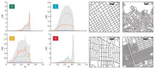
The four groups. (Left) Average distribution of the shape factor F for each group found by the clustering algorithm. (Right) Typical street pattern for each group ( plotted at the same scale in order to observe differences both in shape and areas). Group 1 (top left): Buenos Aires—Group 2: Athens—Group 3: New Orleans—Group 4: Mogadishu. Credit: Journal of the Royal Society Interface, Published 8 October 2014 doi: 10.1098/rsif.2014.0924
(Phys.org) —A pair of researchers, a physicist and a mathematician, has used data from OpenStreetMap and mathematical analysis to come up with the idea that there are only four main types of city topologies. In their paper published in Journal of the Royal Society Interface, Rémi Louf and Marc Barthelemy describe how they used publicly available data to compare the topologies of 131 cities around the world and what their study has revealed.
The two researchers are proposing that all major cities in the world can be represented by one of four topological types based on block sizes, shape and arrangement. The first is a medium-sized grid made up of blocks that are generally grouped as squares or rectangles. The second is where areas are dominated by fractions of smaller blocks that have a variety of shapes. The third is where a city is made up of mostly blocks of medium size that have diverse shapes. And the fourth, they suggest are cities made up of what they describe as mosaic patches that are themselves made up of areas shaped like squares or rectangles. The given shape for a city can be described as a topological fingerprint, the two note, offering clues about its identity.
They also note that when cities are compared using their categories, the old adage that American and European cities tend to be laid out differently holds true, except when they don't. U.S. cities, the duo point out, are generally grid-like, reflecting their young age and preplanning, compared to most cities in Europe. European cities on the other hand, tend to have small city blocks laid out in a wide variety of shapes. But, there are some breaks from the mold—Boston, for example, the researchers note is more similar to European cities. They also note that New York City, with its five Burroughs, is more like several smaller cities from other places in the world, placed together—the Bronx, they say, is laid out in a fashion similar to Porto, Portugal.
Louf and Barthelemy suggest their work provides a quantitative comparison of city street patterns, which they claim allows for better understanding of how and why cities are shaped the way they are.
More information: A typology of street patterns, Journal of the Royal Society Interface, Published 8 October 2014 DOI: 10.1098/rsif.2014.0924
Abstract
We propose a quantitative method to classify cities according to their street pattern. We use the conditional probability distribution of shape factor of blocks with a given area and define what could constitute the 'fingerprint' of a city. Using a simple hierarchical clustering method, these fingerprints can then serve as a basis for a typology of cities. We apply this method to a set of 131 cities in the world, and at an intermediate level of the dendrogram, we observe four large families of cities characterized by different abundances of blocks of a certain area and shape. At a lower level of the classification, we find that most European cities and American cities in our sample fall in their own sub-category, highlighting quantitatively the differences between the typical layouts of cities in both regions. We also show with the example of New York and its different boroughs, that the fingerprint of a city can be seen as the sum of the ones characterizing the different neighbourhoods inside a city. This method provides a quantitative comparison of urban street patterns, which could be helpful for a better understanding of the causes and mechanisms behind their distinct shapes.
Journal information: Journal of the Royal Society Interface
© 2014 Phys.org


