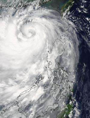
NASA sees Typhoon Kalmaegi as a whirlpool of clouds in the South China Sea

NASA's Aqua satellite observed Typhoon Kalmaegi crossing the South China Sea and a satellite image from the MODIS instrument aboard made it look like a whirlpool of clouds.
On Sunday, September 14, Kalmaegi passed over northern Luzon, Philippines and emerged into the South China Sea. Typhoon Kalmaegi's maximum sustained winds were near 65 knots (75 mph) making it a category one hurricane on the Saffir-Simpson scale as it moved over the Philippines.
On September 15 at 05:15 UTC (1:15 a.m. EDT) the Moderate Resolution Imaging Spectroradiometer aboard NASA's Aqua satellite captured an image of Typhoon Kalmaegi now fully in the South China Sea. The MODIS image showed tight bands of thunderstorms spiraling into the center from the southern quadrant to the northern quadrant, like a giant whirlpool of clouds. The Joint Typhoon Warning Center noted that a large band of thunderstorms were also building around the western edge of the typhoon.
Maximum sustained winds had increased to 75 knots (86.3 mph/18.9 kph) by 1200 UTC (8 a.m. EDT) on September 15. The center was located near 19.1 east latitude and 113.6 east longitude, about 204 nautical miles south of Hong Kong, and was moving west-northwestward at 17 knots (19.5 mph/31.4 kph). Kalmaegi is generating waves up to 22 feet (6.7 km) in the South China Sea.
The Joint Typhoon Warning Center forecast calls for Kalmaegi to graze northern Hainan Island, move through the Gulf of Tonkin and make landfall just north Hanoi late on September 16. Strong Wind signal #3 is currently in effect in Hong Kong.
Provided by NASA's Goddard Space Flight Center


