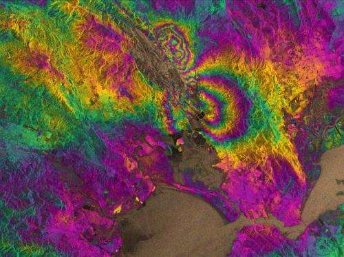
Interferogram of the Califorinia’s Napa region created using two Sentinel-1A images. The two round shapes around Napa valley, which are visible in the central part of the image show how the ground moved during an earthquake on August 24, 2014. Credit: Copernicus data (2014)/ESA/PPO.labs/Norut/COMET-SEOM Insarap study
The European Space Agency (ESA) recently captured stunning images of the earthquake that occurred in California's Napa Valley region on August 24, 2014. The earthquake was the largest to rattle northern California in 25 years.
The beautiful image above is known as an interferogram. It is a photograph created from two different images taken by ESA's Sentinel-1A spacecraft. An interferogram refers to an image that is created by combining light from two different sources and shows how the two light sources interfere with one another. Interferograms are particularly useful when studying shock waves or flowing fluids.
The rainbow-coloured patterns are caused when the ground is deformed by the earthquake, causing changes in how radar signals sent from the spacecraft bounce off the surface. In the earthquake on August 24th, the largest deformation reached more than 10 centimeters and effects were felt over an area of 30 square kilometers.
Earthquakes are a striking example of geological activity on Earth. Astrobiologists study events like earthquakes on our planet in order to determine the role of geological processes in habitability. Events like earthquakes and volcanic eruptions play an important role in cycling elements on Earth that are important to life.
Studying geological processes on Earth can also shed light on how other planets in the Solar System and beyond could support habitable environments for life. In this way, the data collected by missions like ESA's Sentinel spacecraft is important in drawing comparisons between the Earth and other rocky worlds.
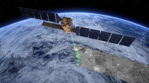
Sentinel-1 carries an advanced synthetic aperture radar that works in several specialised modes to provide detailed imagery for Europe’s Copernicus programme. These data will be used for applications such as monitoring the oceans, including shipping lanes, sea ice and oil spills. It also provides data to map changing land cover, ground deformation, ice shelves and glaciers, and can be used to help emergency response when disasters such as floods strike and to support humanitarian relief efforts at times of crisis. Credit: ESA/ATG medialab
Sentinel-1A is the first in ESA's Sentinel fleet, and was launched on April 3, 2014. This new global monitoring program will collect data about the environment of Earth that will be used to study the effects of climate change and the future habitability of our planet. Sentinel-1A uses its radar instrument to collect images of the Earth's surface both night and day, and during all types of weather. The second spacecraft, Sentinel-2A, is currently set to launch in 2016.
Source: Astrobio.net
This story is republished courtesy of NASA's Astrobiology Magazine. Explore the Earth and beyond at www.astrobio.net .


