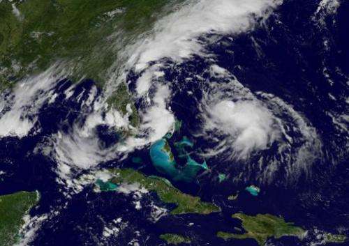
This National Oceanic and Atmospheric Administration (NOAA) satellite GOES East image taken August 4, 2014 shows Hurricane Bertha
Bertha picked up strength Monday to become the second hurricane of the Atlantic season, but the storm is not expected to make landfall on the US East Coast, forecasters said.
In its 1500 GMT bulletin, the National Hurricane Center (NHC) put the center of the hurricane about 230 miles (370 kilometers) east-northeast of Great Abaco Island, in the northern Bahamas.
It was moving towards at 17 miles per hour, with maximum sustained winds of nearly 80 miles per hour and little change in strength expected before Tuesday.
"On the forecast track, Bertha will continue to move away from the Bahamas today and pass about midway between the US east coast and Bermuda on Tuesday," the NHC said.
It earlier said Bertha was expected to drop up to five inches (13 centimeters) of rain across eastern portions of the Dominican Republic, as well as the Turks and Caicos through Monday.
Dominican authorities on Sunday declared a red-alert emergency after heavy rains triggered by Bertha toppled trees and flooded the banks of many rivers in the mountainous nation. No injuries were immediately reported.
The 2014 Atlantic hurricane season, from June 1 to November 30, was expected to be quieter than usual, the NHC has said, with eight to 13 tropical storms—of which three to six could rise to hurricane strength.
The year's first hurricane, named Arthur, swiped the Atlantic seaboard over the July 4 holiday weekend, prompting evacuations in some places with its big waves, strong tidal surges and up to six inches of rain.
Out in the Pacific, another hurricane, dubbed Iselle, was updated to a category 4 storm with sustained winds of 140 miles an hour.
Iselle was on track to pass just north of the Hawaiian of Oahu on Thursday—although forecasters expected it to weaken in the coming days.
© 2014 AFP


