NRL reveals new meteorological insight into mid-level clouds

Research meteorologists at the U.S. Naval Research Laboratory (NRL) Marine Meteorology Division (MMD) and Scripps Institution of Oceanography, employing the Navy's Mid-Course Doppler Radar (MCR) at Cape Canaveral, were able to characterize mid-level, mixed-phase altocumulus clouds.
In altocumulus clouds, at medium altitudes ranging from 6,000 feet to 20,000 feet above mean sea level, water droplets can remain in a supercooled liquid phase at temperatures below zero degrees Celsius, the freezing point of water. The supercooled liquid water found at temperatures generally between 0 and 35 below zero—the temperature where supercooled water droplets begin to spontaneously freeze in a process referred to as homogeneous nucleation—can freeze on contact and thus possibly impact aircraft weapons and sensors or control surfaces effecting flight safety.
"Altocumulus clouds are relatively thin mid-level clouds that cannot be reasonably resolved in current atmospheric models. To mitigate their potential impact on Navy and Department of Defense operations, these clouds must be better parameterized" said Dr. Jerry Schmidt, meteorologist, NRL MMD Mesoscale Modeling Section.
In previous ground breaking research, Schmidt discovered that the MCR—a very high resolution C-band dual polarization radar—is precise and versatile enough to resolve individual ice crystals and raindrops within clouds, making it a unique research tool.
In collaboration with Dr. Piotr Flatau of Scripps Institution of Oceanography and independent radar consultant Robert Yates, the team analyzed coincidental aircraft observations, ground-based instrumentation readings, and radar data from the MCR to document the structure of a thin and narrow band of mixed-phase altocumulus clouds.
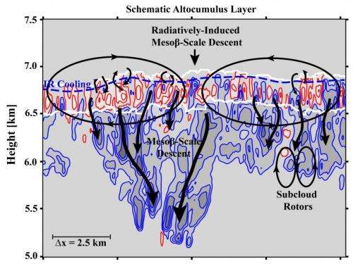
The group then analyzed the diabatic heating and cooling structure of the altocumulus layer associated with the vertical flux divergence of the longwave and shortwave radiation as well as the evaporation and sublimation of liquid and ice particles over a deep virga layer that extended 1500 meters below the cloud base. When analyzing the high-resolution observations of the real-world atmosphere, the study found that actual observed processes did not precisely match with existing cloud formation and dissipation theories.
"In particular, it was found that the presence of layer-wide horizontal gradient in the cloud top radiative cooling rates—associated with the magnitude of the cloud liquid water content—creates a circulating flow in the atmosphere," Schmidt said. "This directs warm and dry air downward over the central portion of the narrow altocumulus cloud band, which begins to evaporate the interior cloud liquid water." Ultimately, the cloud's longevity or demise then hinges on whether or not a quasi-balanced state can arise between the water production terms within the cloud layer and the radiatively-induced mesoscale subsidence circulation the liquid production ultimately creates.
Fully analyzed results and follow-on field experiments will enable NRL scientists to better understand and model the composition, generation and decay of mid-level, and eventually low and high level clouds. The goal is to develop the capability to provide more accurate tactical scale cloud information to Navy and Department of Defense (DoD) mission planners and warfighting decision makers in support of global operations.
Provided by Naval Research Laboratory


