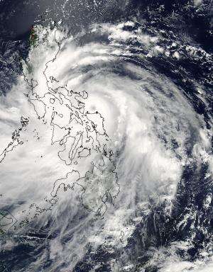
The MODIS instrument aboard NASA's Aqua satellite captured this image of Typhoon Rammasun over the Philippines on July 15 at 05:00 UTC (1 a.m. EDT). The storm's eye was just east of Visayas. Credit: NASA Goddard MODIS Rapid Response, Jeff Schmaltz
Early on July 15, Typhoon Rammasun began making landfall in the eastern part of the central Philippines and NASA's Aqua and TRMM satellites spotted the 20 nautical-mile-wide (23 mile/37 km) eye of the storm close to landfall.
Typhoon Rammasun was making landfall in the Visayas region. Visayas is located in the central Philippines.
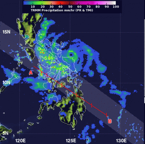
The Tropical Rainfall Measuring Mission or TRMM satellite passed over Rammasun on Tuesday, July 15, 2014 at 04:10 UTC (12:10 a.m. EDT) and measured rainfall occurring throughout the storm. TRMM found moderate rainfall (about 35 mm)/1.4 inches per hour) around the center of circulation and moderate to heavy rainfall (50 mm/2 inches per hour) over the central and northern Philippines in the western quadrant of Rammasun.
When NASA's Aqua satellite flew over Typhoon Rammasun on July 15 at 05:00 UTC (1 a.m. EDT) the Moderate Resolution Imaging Spectroradiometer instrument known as MODIS took a visible image of the storm. The MODIS image showed Rammasun's eye just east of the Visayas region. Rammasun's clouds stretched over the entire country and west into the South China Sea.
TRMM satellite passed over Rammasun on July 15 at 12:10 a.m. EDT and found moderate rainfall (35 mm/1.4 in/hr) around the center and moderate to heavy rainfall (50 mm/2 in/hr) over the central and northern Philippines. Credit: SSAI/NASA, Hal Pierce
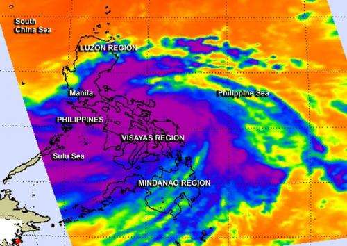
Another instrument aboard Aqua took an infrared picture of Rammasun's cloud top temperatures. The Atmospheric Infrared Sounder gathered temperature data that showed cloud top temperatures exceeded -63F/-52C over the northern and central Philippines and in a band of thunderstorms southeast of the center of circulation over the Philippine Sea. Cloud top temperatures that cold indicate cloud tops high into the troposphere with the potential to produce heavy rainfall. That heavy rainfall was confirmed by NASA's TRMM satellite measurement just 49 minutes earlier when that satellite passed over the Philippines.
On July 15 at 0900 UTC (5 a.m. EDT), Typhoon Rammasun's maximum sustained winds were near 100 knots (115.1 mph/185.2 kph). At that time the center of the storm was closing in on the island of Sorsogon, Philippines. It was centered near 13.2 north latitude and 124.1 east longitude, also about 236 nautical miles (271.6 miles/437.1 km) southeast of Manila. Rammasun is moving to the northwest at 9 knots (10.3 mph/16.6 kph) and is forecast to pass close to Manila early on July 16 (UTC).
The AIRS instrument aboard NASA's Aqua satellite captured this infrared image of powerful thunderstorms (purple) from Rammasun over the Philippines on July 15 at 04:59 UTC (12:59 a.m. EDT) Credit: NASA JPL, Ed Olsen
The Joint Typhoon Warning Center forecasters expect Rammasun to weaken moving over the Philippines and then re-intensify after re-emerging over the South China Sea because of the warm sea surface temperatures there. Rammasun is expected to be a typhoon when it makes a second landfall over northern Hainan Island, China on July 18 before a final landfall in northern Vietnam.
Provided by NASA's Goddard Space Flight Center


