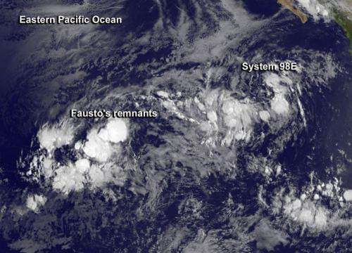
On July 9 at 1500 UTC (11 a.m. EDT) Fausto's circulation was no longer apparent on visible imagery from NOAA's GOES-West satellite and System 98E was located to the east of Fausto. Credit: NASA/NOAA GOES Project
NOAA's GOES-West and NASA-JAXA's Global Precipitation Measurement or GPM mission satellite helped forecasters at the National Hurricane Center determine that what was once Tropical Storm Fausto is now a remnant area of low pressure in the Eastern Pacific Ocean.
Forecaster Beven at the National Hurricane Center (NHC) noted that "satellite imagery, overnight scatterometer data, and a recent GPM satellite microwave overpass indicate that Fausto has degenerated to a trough of low pressure."
On July 9 at 1500 UTC (11 a.m. EDT) Fausto's circulation was no longer apparent on visible imagery from NOAA's GOES-West satellite. The image showed the developing low pressure area known as System 98E, located to the east of Fausto, was slightly more organized today. The GOES-West image was created at NASA/NOAA's GOES Project at NASA's Goddard Space Flight Center in Greenbelt, Md.
The National Hurricane Center issued the final advisory on Fausto at the time of the GOES-West image. At that time, Fausto's remnants were located near 11.7 north latitude and 129.5 west longitude, about 1,505 miles (2,420 km) west-southwest of the southern tip of Baja California. The maximum sustained winds were near 30 mph (45 kph) and weakening. The NHC expects winds associated with the remnants of Fausto should decrease during the next couple of days.The estimated minimum central pressure was 1007 millibars.
The remnants were moving west-northwest near 17 mph (28 kph) and are expected to continue in a general west-northwestward motion for the next several days. Over that time, they will move through an area of increasing vertical wind shear and mid-level dry air which will help them dissipate.
System 98E is located to the east of Fausto's remnants. The broad low pressure area is generating showers. It is located several hundred miles southwest of the southern tip of the Baja California Peninsula and has become better organized today. NHC noted that additional slow development is possible during the next day or so before upper-level winds become less friendly for development.
Provided by NASA's Goddard Space Flight Center


