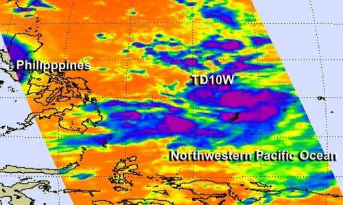
NASA's Aqua satellite passed over Tropical Depression 10W on July 17 and the AIRS instrument aboard captured infrared data that showed powerful thunderstorms (purple) developed around the storm's center. Credit: NASA JPL, Ed Olsen
The tenth tropical depression of the Northwestern Pacific Ocean was born as NASA's Aqua satellite passed overhead.
NASA's Aqua satellite passed over Tropical Depression 10W on July 17, as it came together northwest of the island of Yap. As Aqua passed overhead the Atmospheric Infrared Sounder (AIRS) instrument aboard captured infrared data that showed powerful thunderstorms developed around the storm's center. When AIRS gathered the data on the cloud tops, the temperatures were already as cold as -63F/-52C, indicating strong uplift has pushed them to the top of the troposphere.
At 1500 UTC (11 a.m. EDT) on July 17, the Joint Typhoon Warning Center (JTWC) put the center of the depression near 10.2 north latitude and 135.2 east longitude, about 175 nautical miles (201.4 miles/ 324.1 km) west-northwest of Yap. It had maximum sustained winds near 30 knots (34.5 mph/55.5 kph) and is expected to strengthen. Tropical Depression 10W was crawling to the west at 2 knots (2.3 mph/3.7 kph), but is expected to turn to the northwest in a couple of days.
JTWC noted that "The combined effects of favorable sea surface temperatures (over 80F/26.6C) and improved upper-level conditions will allow the system to further intensify, leading to typhoon strength in five days (by July 22).
Provided by NASA's Goddard Space Flight Center


