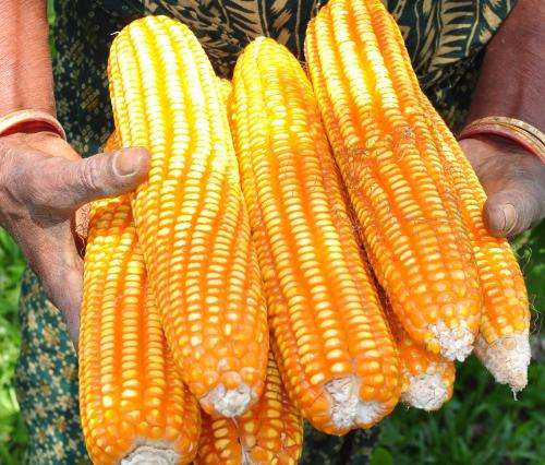
ESA’s Soil Moisture and Ocean Salinity mission has gone beyond its original scientific brief of delivering critical information for understanding the water cycle – this versatile satellite is now being used to predict drought and improve crop yield in regions prone to famine. Credit: B. Mahalder
ESA's Soil Moisture and Ocean Salinity mission has gone beyond its original scientific brief of delivering critical information for understanding the water cycle – this versatile satellite is now being used to predict drought and improve crop yield in regions prone to famine.
The US Department of Agriculture use satellite images and soil moisture data to help identify abnormal weather that may affect the production and yield of crops. Using this information, they publish monthly estimates of world production, supply and distribution.
As well as offering traders and commodity markets a source of unbiased information, these estimates provide decision-makers with critical information for countries that may need food aid as a result of severe droughts.
Identifying when and where there may be a risk of famine involves measuring soil moisture in the 'root-zone' during the growing season, and detecting the onset and severity of drought.
Analysts use information linked to drought from a range of observing systems to compile these crop production forecasts.
In the past, the amount of moisture in the soil available to plants was estimated by integrating daily observations of rainfall and temperatures into computer models of soil–water balance. However, this approach only works reliably in areas where high-quality observations are available.
In large areas of the world, such as southern Africa, there are little or no such data.
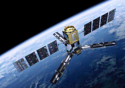
The SMOS mission makes global observations of soil moisture over Earth’s landmasses and salinity over the oceans. Variations in soil moisture and ocean salinity are a consequence of the continuous exchange of water between the oceans, the atmosphere and the land – Earth’s water cycle. Credit: ESA/AOES Medialab
Turning to space, the US Department of Agriculture (USDA) Foreign Agricultural Service has started to incorporate data from ESA's Soil Moisture and Ocean Salinity (SMOS) satellite into their forecasting system.
Carrying a novel sensor, SMOS captures images of 'brightness temperature'. These images correspond to microwave radiation emitted from Earth's surface and can be related to soil moisture and ocean salinity – two key variables in Earth's water cycle.
Through SMOS, the US service obtains timely information on soil moisture patterns, which help to predict how the health of plants will change and, therefore, how productive they will be.
Testing the SMOS readings for this purpose, they received very positive feedback from analysts in southern Africa. This is a challenging area because there are very few working rain gauges.
The new product is available on the Crop Explorer website.
Wade Crow of the USDA said, "SMOS is substantially improving USDA's ability to globally monitor agricultural drought and predict its short-term impact on vegetation health and agricultural yield.
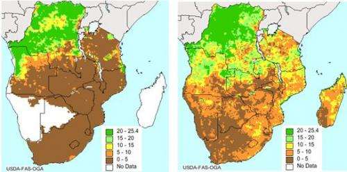
Soil moisture in southern Africa in mid-April 2014. The image on the left is based on rain gauge data only. It shows that data gaps and lack of spatial variability limit the information that can be provided in large areas of Africa to monitor plant health. The more detailed image on the right includes soil moisture data from ESA’s SMOS mission, which are assimilated into the United States Department of Agriculture’s Foreign Agricultural Service forecasting system. This adds significant information in large areas of southern Africa. Credit: USDA FAS
"The positive impact of SMOS is especially significant over data-poor areas of the world prone to food insecurity and famine such as southern Africa."
Matthias Drusch, ESA's SMOS Mission Scientist, added, "Given the excellent quality of the SMOS soil moisture product, we can also expect a positive effect of the observations in other areas such as the Horn of Africa and South America.
"Potentially, India and Central Asia could also benefit from this service if we continue reducing the number of sources of radio-frequency interference in these regions."
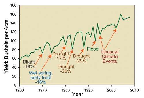
The impact of various factors on annual corn yields in the USA. Drought events are responsible for major year-to-year reductions in agricultural productivity. Accurately monitoring root-zone soil moisture is critical to detect these events early. Image source: 2009 USGCRP NAST report. Credit: USDA FAS
SMOS was built primarily to deliver important information for scientific research, but this is another example of how its measurements are now also being used operationally to benefit economies and societies.
Along with advancing science, this multifaceted mission has already shown its value in mapping thin sea-ice, improving weather forecasts and tracking surface winds under hurricanes. It has now turned its talents to helping tackle a major global concern: food security.
Provided by European Space Agency


