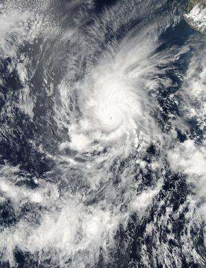
On May 25 at 2100 UTC/5 p.m. EDT the MODIS instrument aboard NASA's Aqua satellite captured this visible image that revealed an eye in Hurricane Amanda. Credit: NASA Goddard MODIS Rapid Response Team
The first tropical cyclone of the Eastern Pacific hurricane season grew into a major hurricane as Hurricane Amanda reached Category 4 status on the Saffir-Simpson scale over the Memorial Day holiday weekend. NASA and NOAA satellites watched as Amanda developed an eye while strengthening.
Fortunately, Amanda is far enough away from coastal Mexico that no watches or warnings are in effect today, May 27.
On Sunday, May 25, Amanda strengthened into the first Major Hurricane in the Eastern Pacific Ocean. Maximum sustained winds were near 155 mph (250 kph). Amanda was centered near 11.8 north and 111.1 west, about 770 miles (1,240 km) south of the southern tip of Baja California. Amanda is a Category 4 on the Saffir-Simpson scale. Minimum central pressure was near 932 millibars, and Amanda was crawling to the north at 2 mph (4 kph). Visible imagery from MODIS (Moderate Resolution Imaging Spectroradiometer) instrument aboard NASA's Aqua satellite and NOAA's GOES-West satellite captured imagery that revealed an eye in Hurricane Amanda.
On Monday, May 26, Hurricane Amanda started to weaken from its peak at a Category 4 status on the Saffir-Simpson scale. An image from NOAA's GOES-West satellite at 1200 UTC/5:00 a.m. PDT showed that Amanda's eye had become cloud-filled. Amanda's maximum sustained winds were near 140 mph (220 kph) and the hurricane was moving to the north-northwest at 7 mph/ (11 kph). Amanda was centered near 13.1 north and 111.6 west, about 685 miles (1,105 km) south of the southern tip of Baja California.
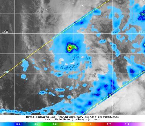
This combination image of TRMM rainfall data and GOES-West infrared data shows heavy rainfall (purple) in the center of Amanda on May 27, falling at 1.4 inches per hour. Credit: NRL/NASA/JAXA/NOAA
On Tuesday, May 26 at 1500 UTC (11 a.m. EDT/8 a.m. PDT), Amanda's maximum sustained winds were near 120 mph (195 kph). Amanda is a category three hurricane on the Saffir-Simpson Hurricane wind scale. Amanda was centered near 14.7 north latitude and 112.3 west longitude, about 585 miles (945 km) south-southwest of the southern tip of Baja California, Mexico. Amanda was moving to the north-northwest at 6 mph (9 kph) and had a minimum central pressure of 957 millibars.
The U.S. Naval Research Laboratory in Washington, D.C. created a composite image using rainfall rate data from NASA-JAXA's Tropical Rainfall Measuring Mission (TRMM) satellite and infrared imagery from NOAA's GOES-West satellite to create a comprehensive look at Amanda. The infrared data showed the cloud extent, and the TRMM data showed heavy rainfall around Amanda's center falling at 1.4 inches (35 mm) per hour.
On Monday, May 26 an image from NOAA's GOES-West satellite at 5:00 a.m. PDT showed that Hurricane Amanda's eye had become cloud-filled. Credit: NASA/NOAA GOES Project
The National Hurricane Center forecasts weakening during the next 48 hours. In fact, NHC forecasters expect Amanda to weaken to a tropical storm by Thursday.
Provided by NASA's Goddard Space Flight Center


