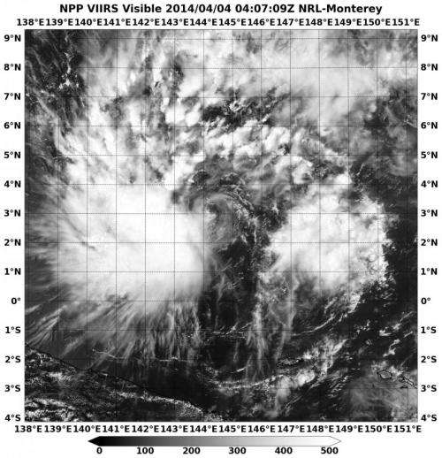
NASA-NOAA's Suomi NPP satellite passed over Tropical Depression 05W on April 4 at 07:09 UTC/3:09 a.m. EDT. Credit: NRL/NASA
NASA-NOAA's Suomi NPP satellite passed over Tropical Depression 05W on April 4 at 07:09 UTC/3:09 a.m. EDT. The VIIRS instrument captured a visible picture of the storm, revealing most of the clouds and thunderstorms were west of the center.
The Joint Typhoon Warning Center or JTWC noted that animated multispectral satellite imagery today, April 3, showed that the low-level circulation center is well-defined and that there is fragmented convective banding of thunderstorms wrapping from the north into the southwest, so most of the strongest convection and thunderstorms are on the western side of the center.
At 0900 UTC/5 a.m. EDT on April 4, Tropical Depression 05W (05W) had maximum sustained winds near 30 knots/35 mph/55 kph. It was located near 3.4 north latitude and 143.7 east longitude, about 629 nautical miles/902.2 miles/1,452 km east-southeast of Koror. The depression is moving to the west at 8 knots/10.3 mph/16.6 kph.
JTWC forecasters noted that 05W is forecast to track in a northwesterly direction through waters with high ocean heat content, so the storm is expected to strengthen into a tropical storm by April 5.
Provided by NASA's Goddard Space Flight Center


