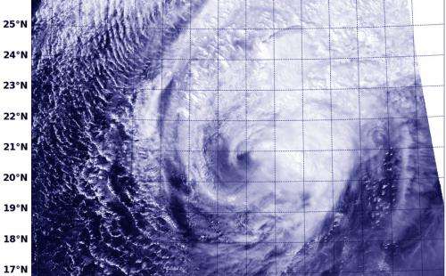
NASA-NOAA's Suomi NPP satellite passed over Tropical Cyclone Faxai, and the VIIRS instrument captured this visible image on Mar. 5 at 03:35 UTC. Credit: US Naval Research Laboratory/NASA/NOAA
When a tropical cyclone becomes elongated it is a sign the storm is weakening. Imagery from NASA-NOAA's Suomi NPP satellite today revealed that wind shear was stretching out Tropical Cyclone Faxai and the storm was waning.
On March 5 at 1500 UTC/10 a.m. EST, Tropical Cyclone Faxai's center was located near 22.5 south and 155.2 east, about 699 nautical miles/804.4 miles/ 1,295 km west-northwest of Wake Island. According to the Joint Typhoon Warning Center or JTWC, Faxai's maximum sustained surface winds dropped to 50 knots/57.5 mph/92.6 kph. Faxai was moving to the northeast at 14 knots/16.1 mph/25.9 kph and quickly weakening.
NASA-NOAA's Suomi NPP satellite passed over Tropical Cyclone Faxai on Mar. 5 at 03:35 UTC and the VIIRS instrument or Visible Infrared Imager Radiometer Suite aboard captured a high-resolution visible image of the storm. VIIRS is a scanning radiometer that collects visible and infrared imagery and radiometric measurements. VIIRS data is used to measure cloud and aerosol properties, ocean color, sea and land surface temperature, ice motion and temperature, fires, and Earth's albedo.
The VIIRS image showed that Faxai had become elongated as a result of increasing vertical wind shear. The VIIRS image also showed cold air stratocumulus clouds were moving into the western quadrant of the storm.
The JTWC noted that all strong convection (rising air that forms thunderstorms that make up a tropical cyclone) has dissipated. Satellite imagery also showed that Faxai was taking on frontal characteristics.
The JTWC issued their final bulletin on Faxai and noted that the storm was expected to become extra-tropical by the end of the day on March 5 as it becomes embedded into a westerly flow.
Provided by NASA's Goddard Space Flight Center


