Researchers have found a clear association between suburbs with extreme heat vulnerability and the number of hospital emergency visits or ambulance call outs on extremely hot days.
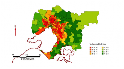
People living in Melbourne's western, inner-northern and south-eastern suburbs are most at risk from heatwaves, according to new research.
Researchers at Monash University have produced a heat vulnerability map for Melbourne that identifies the city's most at-risk suburbs including Sunshine, St Albans, Glenroy, Coburg, Preston, Reservoir, Clayton and Dandenong.
Professor Nigel Tapper from the Cooperative Research Centre (CRC) for Water Sensitive Cities said the map identified Melbourne's postcodes most vulnerable to heat-wave conditions based on risk factors that include lack of tree cover, housing types and the age, health and socio-economic status of the population.
"Our research found a clear association between suburbs with extreme heat vulnerability and the number of hospital emergency visits or ambulance call-outs on extremely hot days," Professor Tapper said.
"We found key factors that raised the risk of sickness or death in heatwaves included older people living alone, ethnicity and the proportion of land covered by buildings that leads to excess urban warmth.
"In areas that are covered by buildings, urban warming occurs that can increase local temperatures by around 4°C. This can take the temperature over the threshold where human health is threatened."
Professor Tapper said heatwaves were a major cause of death in Australia with 374 deaths associated with Melbourne's heatwave in January 2009, and further heat-related deaths in the recent January heatwave.
"The vulnerability maps can be used for emergency response planning by hospitals, the ambulance service and local government to protect vulnerable residents and to plan for the future," Professor Tapper said.
Chief Executive of the Water Sensitive Cities CRC, Professor Tony Wong said providing green spaces and water in the landscape could reduce local temperatures and health risks.
"Promoting lush and well-irrigated vegetation can provide microclimate benefits by reducing excess urban heating through shading and cooling," Professor Wong said.
"For example, prior research found daytime shading provided by street tree canopies improves human comfort by significantly reducing mean radiant temperatures.
"Urban street tree monitoring has shown that during Melbourne heat waves, a person's physiological equivalent temperature (the temperature effectively felt by the body) can be up to 18°C lower near midday in areas with tree canopy shading."
Professor Wong said city planning and urban design should be guided by these heat vulnerability maps.
"We should be planning more green spaces and planting more trees in the high vulnerability areas. Water planners and town planners need to work together to reduce local temperatures," Professor Wong said.
"This would provide long-term citywide resilience to predicted increases in the number and severity of heatwaves in Australian cities."
The CRC's research effort is directed at developing new technologies and urban designs to implement 'green' infrastructure such as trees and waterways and to ensure access to reliable water sources.
To view the heat vulnerability of your suburb visit the Mapping Vulnerability Index website. Areas coloured green on the map indicate the lowest level of vulnerability, while red indicates the highest level of vulnerability.
Provided by Monash University


